
Topografische Karte West Pensacola
Interaktive Karte
Klicken Sie auf die Karte, um die Höhe anzuzeigen.
Über diese Karte
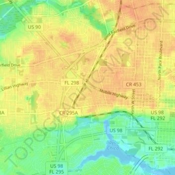
Name: Topografische Karte West Pensacola, Höhe, Relief.
Durchschnittliche Höhe: 20 m
Minimale Höhe: -4 m
Maximale Höhe: 34 m
West Pensacola is located at 30°25′39″N 87°15′39″W / 30.42750°N 87.26083°W / 30.42750; -87.26083 (30.427547, -87.260720), or about 4 miles (6 km) west of downtown Pensacola. The elevation of the CDP is 76 feet above sea level.
Andere topografische Karten
Klicken Sie auf eine Karte, um ihre Topografie, ihre Höhe und ihr Relief anzuzeigen.
Bohemia
United States > Florida > Escambia County > Pensacola
Bohemia, Pensacola, Escambia County, Florida, 32504, United States
Durchschnittliche Höhe: 15 m
Pensacola
United States > Florida > Escambia County > Pensacola
Pensacola, Escambia County, Florida, 32501, United States
Durchschnittliche Höhe: 9 m
East Pensacola Heights
United States > Florida > Escambia County > Pensacola
East Pensacola Heights, Pensacola, Escambia County, Florida, 32520, United States
Durchschnittliche Höhe: 8 m
Gull Point
United States > Florida > Escambia County > Pensacola > Gull Point
Gull Point, Pensacola, Escambia County, Florida, 32504, United States
Durchschnittliche Höhe: 10 m