
Topografische Karte Mount Simeon Subdistrict
Interaktive Karte
Klicken Sie auf die Karte, um die Höhe anzuzeigen.
Über diese Karte
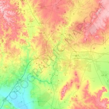
Name: Topografische Karte Mount Simeon Subdistrict, Höhe, Relief.
Durchschnittliche Höhe: 410 m
Minimale Höhe: 260 m
Maximale Höhe: 582 m
Andere topografische Karten
Klicken Sie auf eine Karte, um ihre Topografie, ihre Höhe und ihr Relief anzuzeigen.
Aleppo
Aleppo, Mount Simeon Subdistrict, Mount Simeon District, Aleppo Governorate, Syria
Durchschnittliche Höhe: 413 m
`Arbid
`Arbid, Eastern Kuweires Subdistrict, Deir Hafer ِِDistrict, Aleppo Governorate, Syria
Durchschnittliche Höhe: 367 m
Saharij
Saharij, Sarin Subdistrict, Ayn Al-Arab (Kobani) District, Aleppo Governorate, Syria
Durchschnittliche Höhe: 453 m
Kobani
Syria > Aleppo Governorate > Kobani
Kobani, Ayn Al-Arab (Kobani) Subistrict, Ayn Al-Arab (Kobani) District, Aleppo Governorate, Syria
Durchschnittliche Höhe: 522 m
Dayr Hafir
Syria > Aleppo Governorate > Manbij > Dayr Hafir
Dayr Hafir, Manbij, Aleppo Governorate, Syria
Durchschnittliche Höhe: 344 m
Hader
Syria > Aleppo Governorate > Hader
Hader, Al-Hadher Subdistrict, Mount Simeon District, Aleppo Governorate, Syria
Durchschnittliche Höhe: 279 m