
Topografische Karte Richmond
Interaktive Karte
Klicken Sie auf die Karte, um die Höhe anzuzeigen.
Über diese Karte
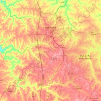
Name: Topografische Karte Richmond, Höhe, Relief.
Ort: Richmond, Madison County, Kentucky, 40475, United States (37.62352 -84.34202 37.79452 -84.24014)
Durchschnittliche Höhe: 281 m
Minimale Höhe: 204 m
Maximale Höhe: 323 m
Andere topografische Karten
Klicken Sie auf eine Karte, um ihre Topografie, ihre Höhe und ihr Relief anzuzeigen.
Berea
United States > Kentucky > Madison County
Berea, Madison County, Kentucky, United States
Durchschnittliche Höhe: 300 m
Redhouse
United States > Kentucky > Madison County
Redhouse, Madison County, Kentucky, United States
Durchschnittliche Höhe: 248 m
Newby
United States > Kentucky > Madison County
Newby, Madison County, Kentucky, United States
Durchschnittliche Höhe: 272 m
Welch Mountain
United States > Kentucky > Madison County
Welch Mountain, Madison County, Kentucky, 40404, United States
Durchschnittliche Höhe: 315 m
Fort Boonesborough State Park
United States > Kentucky > Madison County > Boonesborough
Fort Boonesborough State Park, Boonesborough, Madison County, Kentucky, United States
Durchschnittliche Höhe: 236 m
Berea
United States > Kentucky > Madison County > Berea > Berea
Berea, Madison County, Kentucky, 40404, United States
Durchschnittliche Höhe: 314 m
Richmond
United States > Kentucky > Madison County > Richmond
Richmond, Madison County, Kentucky, 40475, United States
Durchschnittliche Höhe: 267 m