
Topografische Karte Oakdale
Interaktive Karte
Klicken Sie auf die Karte, um die Höhe anzuzeigen.
Oakdale
Historically the area has been used for orchards and other agricultural uses. Some of the common soil types found in Oakdale are Delhi sand, Oakdale sandy loam, Hanford sandy loam, and Tujunga loamy sand. Oakdale is generally on level ground at an elevation of approximately 190 feet (58 m) above mean sea level. Drainage is generally to the northwest towards the Stanislaus River.
Über diese Karte
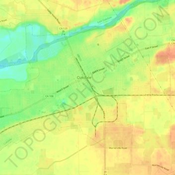
Name: Topografische Karte Oakdale, Höhe, Relief.
Durchschnittliche Höhe: 52 m
Minimale Höhe: 26 m
Maximale Höhe: 69 m
Andere topografische Karten
Klicken Sie auf eine Karte, um ihre Topografie, ihre Höhe und ihr Relief anzuzeigen.
San Joaquin River National Wildlife Refuge
United States > California > Stanislaus County
Durchschnittliche Höhe: 14 m