
Topografische Karte Reserve
Interaktive Karte
Klicken Sie auf die Karte, um die Höhe anzuzeigen.
Über diese Karte
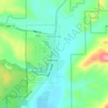
Name: Topografische Karte Reserve, Höhe, Relief.
Ort: Reserve, Catron County, New Mexico, United States (33.70165 -108.76645 33.71615 -108.75625)
Durchschnittliche Höhe: 1.780 m
Minimale Höhe: 1.735 m
Maximale Höhe: 1.890 m
Reserve has a Mediterranean climate of the warm-summer type (Köppen: Csb), unusual in New Mexico. Despite having mild to hot daytime highs year round, temperatures substantially cool off during nighttime due to Reserve's high elevation and aridity. Even in the summertime, 90 degree days can cool off into the 40's. A freeze has been recorded every month of the year except August. Reserve receives most of its rainfall in the form of thunderstorms from mid-summer into fall from the North American Monsoon, which can produce hazardous flash floods very quickly. Snow usually falls once or twice a year, but melts quickly due to the high daytime temperatures.
Andere topografische Karten
Klicken Sie auf eine Karte, um ihre Topografie, ihre Höhe und ihr Relief anzuzeigen.
Prairie Lake
United States > New Mexico > Catron County
Prairie Lake, Catron County, New Mexico, United States
Durchschnittliche Höhe: 2.342 m
San Francisco
United States > New Mexico > Catron County
San Francisco, Catron County, New Mexico, United States
Durchschnittliche Höhe: 2.440 m
Quemado
United States > New Mexico > Catron County
Quemado, Catron County, New Mexico, United States
Durchschnittliche Höhe: 2.113 m
Alma
United States > New Mexico > Catron County
Alma, Catron County, New Mexico, United States
Durchschnittliche Höhe: 1.535 m
Capital Dome
United States > New Mexico > Catron County
Capital Dome, Catron County, New Mexico, United States
Durchschnittliche Höhe: 2.459 m
Cruzville
United States > New Mexico > Catron County
Cruzville, Catron County, New Mexico, United States
Durchschnittliche Höhe: 1.975 m
Datil
United States > New Mexico > Catron County
Datil, Catron County, New Mexico, United States
Durchschnittliche Höhe: 2.279 m
Gila Wilderness
United States > New Mexico > Catron County
Gila Wilderness, Catron County, New Mexico, United States
Durchschnittliche Höhe: 2.085 m
Pie Town
United States > New Mexico > Catron County
Pie Town, Catron County, New Mexico, 87827, United States
Durchschnittliche Höhe: 2.352 m
San Francisco Mountains
United States > New Mexico > Catron County
San Francisco Mountains, Catron County, New Mexico, United States
Durchschnittliche Höhe: 2.541 m