
Topografische Karte Garzón
Interaktive Karte
Klicken Sie auf die Karte, um die Höhe anzuzeigen.
Über diese Karte
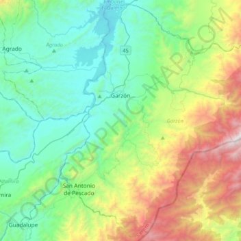
Name: Topografische Karte Garzón, Höhe, Relief.
Durchschnittliche Höhe: 1.366 m
Minimale Höhe: 654 m
Maximale Höhe: 3.277 m
Garzón limita por el norte con el municipio de Gigante, por el sur con el municipio de Guadalupe, al suroeste con los municipios de Altamira; por el oriente con el departamento del Caquetá y por el occidente con el municipio de Agrado. Debido a su topografía, se encuentra subdividida en distintas regiones:
Andere topografische Karten
Klicken Sie auf eine Karte, um ihre Topografie, ihre Höhe und ihr Relief anzuzeigen.
Buenos Aires
Buenos Aires, Palermo, Norte, Huila, RAP (Especial) Central, Colombia
Durchschnittliche Höhe: 801 m
Naranjos
Colombia > Huila > San Agustin
Naranjos, San Agustin, San Agustín, Sur, Huila, Región Andina, 418060, Colombia
Durchschnittliche Höhe: 1.603 m
San Rafael
San Rafael, Lourdes, La Argentina, Huila, Colombia
Durchschnittliche Höhe: 1.859 m
Ceibas
Colombia > Huila > Pital > El Cauchal
Ceibas, Pital, Huila, Colombia
Durchschnittliche Höhe: 1.450 m
Nueva Irlanda
Colombia > Huila > Nueva Irlanda
Nueva Irlanda, La Plata, Huila, Colombia
Durchschnittliche Höhe: 1.632 m