
Topografische Karte Roberts County
Interaktive Karte
Klicken Sie auf die Karte, um die Höhe anzuzeigen.
Über diese Karte
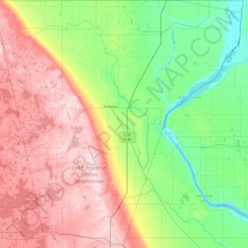
Name: Topografische Karte Roberts County, Höhe, Relief.
Ort: Roberts County, South Dakota, USA (45.29917 -97.23138 45.93599 -96.47199)
Durchschnittliche Höhe: 429 m
Minimale Höhe: 293 m
Maximale Höhe: 643 m
Andere topografische Karten
Klicken Sie auf eine Karte, um ihre Topografie, ihre Höhe und ihr Relief anzuzeigen.
Missouri River
Missouri River, Sully County, South Dakota, 64072, USA
Durchschnittliche Höhe: 901 m
Sisseton
USA > South Dakota > Sisseton
Sisseton, Roberts County, South Dakota, 57262, USA
Durchschnittliche Höhe: 376 m
Angostura Recreation Area
Angostura Recreation Area, Fall River County, South Dakota, USA
Durchschnittliche Höhe: 990 m
Hutchinson County
Hutchinson County, South Dakota, USA
Durchschnittliche Höhe: 426 m