
Topografische Karte Corregidora
Interaktive Karte
Klicken Sie auf die Karte, um die Höhe anzuzeigen.
Über diese Karte
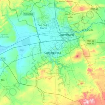
Name: Topografische Karte Corregidora, Höhe, Relief.
Ort: Corregidora, Querétaro, 76900, México (20.37995 -100.60129 20.69995 -100.28129)
Durchschnittliche Höhe: 1.973 m
Minimale Höhe: 1.779 m
Maximale Höhe: 2.575 m
Andere topografische Karten
Klicken Sie auf eine Karte, um ihre Topografie, ihre Höhe und ihr Relief anzuzeigen.
Vista Real
México > Querétaro > Corregidora > El Progreso (Las Trojas)
Vista Real, El Progreso (Las Trojas), Corregidora, Querétaro, México
Durchschnittliche Höhe: 2.037 m
El Pueblito
México > Querétaro > Corregidora
El Pueblito, Corregidora, Querétaro, 76900, México
Durchschnittliche Höhe: 1.865 m
Presa EL Batan
México > Querétaro > Corregidora > San Francisco > Vistalago
Presa EL Batan, Vistalago, San Francisco, Corregidora, Querétaro, México
Durchschnittliche Höhe: 1.957 m
San Francisco
México > Querétaro > Corregidora > San Francisco
San Francisco, Corregidora, Querétaro, 76904, México
Durchschnittliche Höhe: 1.964 m
El Progreso (Las Trojas)
México > Querétaro > Corregidora
El Progreso (Las Trojas), Corregidora, Querétaro, 76904, México
Durchschnittliche Höhe: 1.997 m
Purísima de San Rafael
México > Querétaro > Corregidora > Purísima de San Rafael
Purísima de San Rafael, Corregidora, Querétaro, 76950, México
Durchschnittliche Höhe: 1.959 m
Candiles
México > Querétaro > Corregidora
Candiles, Corregidora, Querétaro, 76904, México
Durchschnittliche Höhe: 1.909 m