
Spenden
Rüsten Sie sich für Ihr nächstes Abenteuer:
Als Amazon-Partner erhält diese Website eine Provision für qualifizierte Käufe, ohne zusätzliche Kosten für Sie.
Topografische Karte Putanges-Pont-Écrepin
Klicken Sie auf die Karte, um die Höhe anzuzeigen.
Spenden
Rüsten Sie sich für Ihr nächstes Abenteuer:
Als Amazon-Partner erhält diese Website eine Provision für qualifizierte Käufe, ohne zusätzliche Kosten für Sie.
Putanges-Pont-Écrepin
Cependant, il faut prendre put au sens non pas de « sale », mais plutôt de « mauvais » (signification que sale peut aussi avoir). Deux anciens lieux-dits de Lisieux portent le nom de Putangle (de Puto angulo 1200, Putangle 1267) et Bonangle (Bone Angle 1293, Bon Angle 1326), ce dernier devenu aujourd'hui la rue Bon Ange. Il s'agit de deux coins de l'ancienne île Saint-Dominique sur la Touques, le put angle « mauvais coin » est formé par le coude dangereux ou malcommode de la rivière, et le bon angle « bon coin » s'oppose ainsi à lui. La topographie à Putanges est identique puisqu'il est situé sur une courbe prononcée de l'Orne.
Spenden
Rüsten Sie sich für Ihr nächstes Abenteuer:
Als Amazon-Partner erhält diese Website eine Provision für qualifizierte Käufe, ohne zusätzliche Kosten für Sie.
Über diese Karte
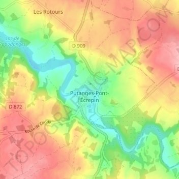
Name: Topografische Karte Putanges-Pont-Écrepin, Höhe, Relief.
Durchschnittliche Höhe: 186 m
Minimale Höhe: 119 m
Maximale Höhe: 248 m
Spenden
Rüsten Sie sich für Ihr nächstes Abenteuer:
Als Amazon-Partner erhält diese Website eine Provision für qualifizierte Käufe, ohne zusätzliche Kosten für Sie.
Andere topografische Karten
Klicken Sie auf eine Karte, um ihre Topografie, ihre Höhe und ihr Relief anzuzeigen.
Lac de Rabodanges
France > Normandie > Orne > Putanges-le-Lac > Sainte-Croix-sur-Orne
Durchschnittliche Höhe: 176 m
Le Châtelier
France > Normandie > Orne > Putanges-le-Lac > Putanges-Pont-Écrepin
Durchschnittliche Höhe: 186 m
Le Buisson
France > Normandie > Orne > Putanges-le-Lac > Putanges-Pont-Écrepin
Durchschnittliche Höhe: 191 m
Spenden
Rüsten Sie sich für Ihr nächstes Abenteuer:
Als Amazon-Partner erhält diese Website eine Provision für qualifizierte Käufe, ohne zusätzliche Kosten für Sie.
Les Courtils
France > Normandie > Orne > Putanges-le-Lac > Putanges-Pont-Écrepin
Durchschnittliche Höhe: 186 m
Le Hamel
France > Normandie > Orne > Putanges-le-Lac > La Forêt-Auvray > Le Hamel
Durchschnittliche Höhe: 173 m
Lac de Rabodanges
France > Normandie > Orne > Putanges-le-Lac > Sainte-Croix-sur-Orne
Durchschnittliche Höhe: 176 m
Spenden
Rüsten Sie sich für Ihr nächstes Abenteuer:
Als Amazon-Partner erhält diese Website eine Provision für qualifizierte Käufe, ohne zusätzliche Kosten für Sie.