
Topografische Karte Zemplín
Interaktive Karte
Klicken Sie auf die Karte, um die Höhe anzuzeigen.
Über diese Karte
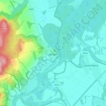
Name: Topografische Karte Zemplín, Höhe, Relief.
Durchschnittliche Höhe: 116 m
Minimale Höhe: 87 m
Maximale Höhe: 242 m
The village lies at an altitude of 106 metres and covers an area of 14,67 km². It is located near the junction point of the rivers Ondava and Latorica (tributaries of the river Bodrog) in eastern Slovakia.
Andere topografische Karten
Klicken Sie auf eine Karte, um ihre Topografie, ihre Höhe und ihr Relief anzuzeigen.
Borša
Slovakia > Region of Košice > District of Trebišov
Borša, District of Trebišov, Region of Košice, Eastern Slovakia, 076 32, Slovakia
Durchschnittliche Höhe: 114 m
Kysta
Slovakia > Region of Košice > District of Trebišov
Kysta, District of Trebišov, Region of Košice, Eastern Slovakia, Slovakia
Durchschnittliche Höhe: 177 m
Boťany
Slovakia > Region of Košice > District of Trebišov
Boťany, District of Trebišov, Region of Košice, Eastern Slovakia, 076 43, Slovakia
Durchschnittliche Höhe: 101 m
Borša
Slovakia > Region of Košice > District of Trebišov > Borša > Borša
Borša, District of Trebišov, Region of Košice, Eastern Slovakia, 076 32, Slovakia
Durchschnittliche Höhe: 110 m