
Topografische Karte Palmas
Interaktive Karte
Klicken Sie auf die Karte, um die Höhe anzuzeigen.
Über diese Karte
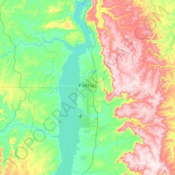
Name: Topografische Karte Palmas, Höhe, Relief.
Durchschnittliche Höhe: 367 m
Minimale Höhe: 189 m
Maximale Höhe: 711 m
Palmas is located at the state's geographic centre at an average altitude of 230 m (755 ft). The city is located between the Serra do Lajeado hills on the east and the Tocantins River on the west. Palmas has a metropolitan area with 471,639 inhabitants.
Andere topografische Karten
Klicken Sie auf eine Karte, um ihre Topografie, ihre Höhe und ihr Relief anzuzeigen.
Santa Maria do Tocantins
Brazil > Tocantins > Santa Maria do Tocantins
Santa Maria do Tocantins, Microrregião de Porto Nacional, Mesorregião Oriental do Tocantins, Tocantins, North Region, Brazil
Durchschnittliche Höhe: 264 m