
Spenden
Rüsten Sie sich für Ihr nächstes Abenteuer:
Als Amazon-Partner erhält diese Website eine Provision für qualifizierte Käufe, ohne zusätzliche Kosten für Sie.
Topografische Karte Lake Te Au
Klicken Sie auf die Karte, um die Höhe anzuzeigen.
Spenden
Rüsten Sie sich für Ihr nächstes Abenteuer:
Als Amazon-Partner erhält diese Website eine Provision für qualifizierte Käufe, ohne zusätzliche Kosten für Sie.
Über diese Karte
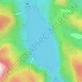
Name: Topografische Karte Lake Te Au, Höhe, Relief.
Durchschnittliche Höhe: 597 m
Minimale Höhe: 342 m
Maximale Höhe: 1.185 m
Spenden
Rüsten Sie sich für Ihr nächstes Abenteuer:
Als Amazon-Partner erhält diese Website eine Provision für qualifizierte Käufe, ohne zusätzliche Kosten für Sie.
Andere topografische Karten
Klicken Sie auf eine Karte, um ihre Topografie, ihre Höhe und ihr Relief anzuzeigen.
Mount Tūtoko
Neuseeland > Southland > Southland District > Fiordland Community
Durchschnittliche Höhe: 1.892 m
Milford Sound / Piopiotahi
Neuseeland > Southland > Southland District > Fiordland Community
Der zwischen 455 m und knapp 3 km breite Fjord deckt eine Fläche von rund 25,3 km² ab und misst an seiner tiefsten Stelle eine Tiefe von 269 m, von wo aus sich die angrenzenden Berge teils sehr steil, bis zu zwischen 60 und 80 Grad ansteigend, mit dem Mitre Peak auf bis zu 1683 m Höhe erheben.
Durchschnittliche Höhe: 655 m