
Topografische Karte Buhay na Sapa
Interaktive Karte
Klicken Sie auf die Karte, um die Höhe anzuzeigen.
Über diese Karte
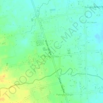
Name: Topografische Karte Buhay na Sapa, Höhe, Relief.
Ort: Buhay na Sapa, San Juan, Batangas, Calabarzon, Philippines (13.78195 121.39202 13.80145 121.41710)
Durchschnittliche Höhe: 18 m
Minimale Höhe: 6 m
Maximale Höhe: 35 m
Andere topografische Karten
Klicken Sie auf eine Karte, um ihre Topografie, ihre Höhe und ihr Relief anzuzeigen.
Malaking Tubig River
Philippines > Batangas > San Juan > Janaojanao
Malaking Tubig River, Janaojanao, San Juan, 2nd District, Batangas, Calabarzon, Philippines
Durchschnittliche Höhe: 19 m
Lawaye
Philippines > Batangas > San Juan > Pinagbayanan
Lawaye, Pinagbayanan, San Juan, Batangas, Calabarzon, Philippines
Durchschnittliche Höhe: 5 m
Putingbuhangin River
Philippines > Batangas > San Juan > Laiya-Aplaya
Putingbuhangin River, Laiya-Aplaya, San Juan, Batangas, Calabarzon, Philippines
Durchschnittliche Höhe: 264 m
Quipot
Philippines > Batangas > San Juan
Quipot, San Juan, Batangas, Calabarzon, Philippines
Durchschnittliche Höhe: 106 m
Talahiban II
Philippines > Batangas > San Juan
Talahiban II, San Juan, Batangas, Calabarzon, Philippines
Durchschnittliche Höhe: 15 m
Bulihan
Philippines > Batangas > San Juan > Janaojanao > Bulihan
Bulihan, Janaojanao, San Juan, Batangas, Calabarzon, 4226, Philippines
Durchschnittliche Höhe: 22 m
Catmon
Philippines > Batangas > San Juan > Catmon
Catmon, San Juan, Batangas, Calabarzon, Philippines
Durchschnittliche Höhe: 2 m
Imelda
Philippines > Batangas > San Juan > Imelda
Imelda, San Juan, Batangas, Calabarzon, 4226, Philippines
Durchschnittliche Höhe: 19 m
Sampiro
Philippines > Batangas > San Juan
Sampiro, San Juan, Batangas, Calabarzon, Philippines
Durchschnittliche Höhe: 46 m