
Topografische Karte Wheeler Peak
Interaktive Karte
Klicken Sie auf die Karte, um die Höhe anzuzeigen.
Über diese Karte
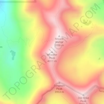
Name: Topografische Karte Wheeler Peak, Höhe, Relief.
Ort: Wheeler Peak, Taos County, New Mexico, United States (36.55684 -105.41686 36.55694 -105.41676)
Durchschnittliche Höhe: 3.674 m
Minimale Höhe: 3.234 m
Maximale Höhe: 3.995 m
Wheeler Peak is the highest natural point in the U.S. state of New Mexico. It is located northeast of Taos and south of Red River in the northern part of the state, and just 2 miles (3.2 km) southeast of the ski slopes of Taos Ski Valley. It lies in the Sangre de Cristo Mountains, the southernmost subrange of the Rocky Mountains. The peak's elevation is 13,167 feet (4,013 m).
Andere topografische Karten
Klicken Sie auf eine Karte, um ihre Topografie, ihre Höhe und ihr Relief anzuzeigen.
Taos
United States > New Mexico > Taos County
Taos, Taos County, New Mexico, United States
Durchschnittliche Höhe: 2.180 m
Ojo Caliente
United States > New Mexico > Taos County
Ojo Caliente, Taos County, New Mexico, 87549, United States
Durchschnittliche Höhe: 1.950 m
Taos Ski Valley
United States > New Mexico > Taos County
Taos Ski Valley, Taos County, New Mexico, United States
Durchschnittliche Höhe: 3.229 m
Anderson Park
United States > New Mexico > Taos County
Anderson Park, Taos County, New Mexico, United States
Durchschnittliche Höhe: 3.219 m
Guadalupe Mountain
United States > New Mexico > Taos County
Guadalupe Mountain, Taos County, New Mexico, 87519, United States
Durchschnittliche Höhe: 2.448 m
Sipapu
United States > New Mexico > Taos County
Sipapu, Taos County, New Mexico, United States
Durchschnittliche Höhe: 2.754 m
Taos Ski Valley
United States > New Mexico > Taos County
Taos Ski Valley, Taos County, New Mexico, United States
Durchschnittliche Höhe: 3.307 m
Gold Hill
United States > New Mexico > Taos County
Gold Hill, Taos County, New Mexico, United States
Durchschnittliche Höhe: 3.568 m
Tres Piedras
United States > New Mexico > Taos County
Tres Piedras, Taos County, New Mexico, United States
Durchschnittliche Höhe: 2.476 m
Cabresto Lake
United States > New Mexico > Taos County
Cabresto Lake, Taos County, New Mexico, United States
Durchschnittliche Höhe: 2.933 m
Arroyo Hondo
United States > New Mexico > Taos County
Arroyo Hondo, Taos County, New Mexico, 87513, United States
Durchschnittliche Höhe: 2.135 m
Ute Mountain
United States > New Mexico > Taos County
Ute Mountain, Taos County, New Mexico, United States
Durchschnittliche Höhe: 2.775 m
Red River
United States > New Mexico > Taos County
Red River, Taos County, New Mexico, United States
Durchschnittliche Höhe: 2.812 m
Ranchos de Taos
United States > New Mexico > Taos County
Ranchos de Taos, Taos County, New Mexico, 87550, United States
Durchschnittliche Höhe: 2.119 m
San Cristobal
United States > New Mexico > Taos County
San Cristobal, Taos County, New Mexico, 87564, United States
Durchschnittliche Höhe: 2.315 m
Peñasco
United States > New Mexico > Taos County
Peñasco, Taos County, New Mexico, 87553, United States
Durchschnittliche Höhe: 2.355 m
Pot Creek
United States > New Mexico > Taos County
Pot Creek, Taos County, New Mexico, United States
Durchschnittliche Höhe: 2.383 m
Ojito
United States > New Mexico > Taos County
Ojito, Taos County, New Mexico, 87543, United States
Durchschnittliche Höhe: 2.431 m
Questa
United States > New Mexico > Taos County
Questa, Taos County, New Mexico, 87556, United States
Durchschnittliche Höhe: 2.339 m
Carson
United States > New Mexico > Taos County
Carson, Taos County, New Mexico, 87517, United States
Durchschnittliche Höhe: 2.082 m
Rio Hondo
United States > New Mexico > Taos County > Taos Ski Valley
Rio Hondo, Taos Ski Valley, Taos County, New Mexico, 87525, United States
Durchschnittliche Höhe: 3.119 m
Rio Grande Rift Historical Marker
United States > New Mexico > Taos County
Rio Grande Rift Historical Marker, Taos County, New Mexico, United States
Durchschnittliche Höhe: 2.160 m
Red River
United States > New Mexico > Taos County
Red River, Taos County, New Mexico, United States
Durchschnittliche Höhe: 2.846 m
Taos
United States > New Mexico > Taos County > Taos
Taos, Taos County, New Mexico, 87571, United States
Durchschnittliche Höhe: 2.173 m
El Prado
United States > New Mexico > Taos County
El Prado, Taos County, New Mexico, 87571, United States
Durchschnittliche Höhe: 2.145 m