Geolokalisieren
👉 Easily get elevation data in JSON, GeoTIFF and KML formats using Elevation API
Vielen Dank für die Unterstützung dieser Website ❤️
Spenden

Topografische Karte Faridkot

Klicken Sie auf die Karte, um die Höhe anzuzeigen.

Faridkot

The average elevation is 196 metres (643 ft). The town is located on the Punjab Plains, which in a macro regional context forms a part of greater Satluj Ganga plain. It is a low-lying flat area. The surface of the district is depositional plain which was formed by alleviation by the rivers flowing in these plains. Sirhind Feeder and Indira Gandhi Canal pass through the district. The topography of the district is plain, with only 1.4% of its area under forest cover.

Wikipedia (CC-BY-SA 3.0)

👉 Easily get elevation data in JSON, GeoTIFF and KML formats using Elevation API
Vielen Dank für die Unterstützung dieser Website ❤️
Spenden

Über diese Karte

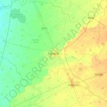
Name: Topografische Karte Faridkot, Höhe, Relief.

Ort: Faridkot, Faridkot Tahsil, Faridkot, Punjab, 151200, India (30.51298 74.59170 30.83298 74.91170)

Durchschnittliche Höhe: 204 m

Minimale Höhe: 193 m

Maximale Höhe: 216 m

👉 Easily get elevation data in JSON, GeoTIFF and KML formats using Elevation API
Vielen Dank für die Unterstützung dieser Website ❤️
Spenden

Rüsten Sie sich für Ihr nächstes Abenteuer:

👕Merino-Funktionswäsche - Natürliche Thermoregulation für jede Jahreszeit
🔭Leichte Reisestative - Stabile Basis für Fotos und Spektive bei geringem Gewicht
👖Outdoor-Hosen - Atmungsaktive und robuste Hosen für Bergsteiger
🧥Softshell Jacke Outdoor - Flexibel und winddicht für wechselhaftes Wetter
🗺️Topographische Karten Europa - Hochwertige Topo‑Karten für Europa im Taschenformat

Als Amazon-Partner erhält diese Website eine Provision für qualifizierte Käufe, ohne zusätzliche Kosten für Sie.