
Topografische Karte Malgas
Interaktive Karte
Klicken Sie auf die Karte, um die Höhe anzuzeigen.
Über diese Karte
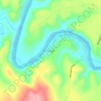
Name: Topografische Karte Malgas, Höhe, Relief.
Durchschnittliche Höhe: 47 m
Minimale Höhe: 1 m
Maximale Höhe: 126 m
Andere topografische Karten
Klicken Sie auf eine Karte, um ihre Topografie, ihre Höhe und ihr Relief anzuzeigen.
Koedoeskop
South Africa > Western Cape > Overberg District Municipality > Swellendam Local Municipality
Koedoeskop, Swellendam Local Municipality, Overberg District Municipality, Western Cape, South Africa
Durchschnittliche Höhe: 608 m
Stormsvlei
South Africa > Western Cape > Overberg District Municipality > Swellendam Local Municipality
Stormsvlei, Swellendam Ward 1, Swellendam Local Municipality, Overberg District Municipality, Western Cape, South Africa
Durchschnittliche Höhe: 148 m
Suurbraak
South Africa > Western Cape > Overberg District Municipality > Swellendam Local Municipality
Suurbraak, Swellendam Ward 3, Swellendam Local Municipality, Overberg District Municipality, Western Cape, South Africa
Durchschnittliche Höhe: 171 m
Spitskop
South Africa > Western Cape > Overberg District Municipality > Swellendam Local Municipality
Spitskop, Swellendam Local Municipality, Overberg District Municipality, Western Cape, South Africa
Durchschnittliche Höhe: 541 m
Ouplaas
South Africa > Western Cape > Overberg District Municipality > Swellendam Local Municipality > Ouplaas
Ouplaas, Swellendam Local Municipality, Overberg District Municipality, Western Cape, South Africa
Durchschnittliche Höhe: 135 m
Swellendam Local Municipality
South Africa > Western Cape > Overberg District Municipality > Swellendam Local Municipality
Swellendam Local Municipality, Overberg District Municipality, Western Cape, South Africa
Durchschnittliche Höhe: 353 m
Boosmansbos
South Africa > Western Cape > Overberg District Municipality > Swellendam Local Municipality
Boosmansbos, Swellendam Ward 2, Swellendam Local Municipality, Overberg District Municipality, Western Cape, South Africa
Durchschnittliche Höhe: 1.123 m
Barrydale
South Africa > Western Cape > Overberg District Municipality > Swellendam Local Municipality
Barrydale, Swellendam Local Municipality, Overberg District Municipality, Western Cape, 6750, South Africa
Durchschnittliche Höhe: 425 m
Klip River
South Africa > Western Cape > Overberg District Municipality > Swellendam Local Municipality > Swellendam
Klip River, Swellendam, Swellendam Local Municipality, Overberg District Municipality, Western Cape, 6470, South Africa
Durchschnittliche Höhe: 324 m
Swellendam
South Africa > Western Cape > Overberg District Municipality > Swellendam Local Municipality
Swellendam, Swellendam Local Municipality, Overberg District Municipality, Western Cape, 6470, South Africa
Durchschnittliche Höhe: 232 m
Keurbooms River
South Africa > Western Cape > Overberg District Municipality > Swellendam Local Municipality > Swellendam
Keurbooms River, Swellendam, Swellendam Local Municipality, Overberg District Municipality, Western Cape, South Africa
Durchschnittliche Höhe: 334 m