
Spenden
Rüsten Sie sich für Ihr nächstes Abenteuer:
Als Amazon-Partner erhält diese Website eine Provision für qualifizierte Käufe, ohne zusätzliche Kosten für Sie.
Topografische Karte Garešnica
Klicken Sie auf die Karte, um die Höhe anzuzeigen.
Spenden
Rüsten Sie sich für Ihr nächstes Abenteuer:
Als Amazon-Partner erhält diese Website eine Provision für qualifizierte Käufe, ohne zusätzliche Kosten für Sie.
Über diese Karte
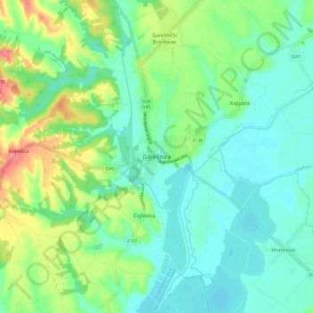
Name: Topografische Karte Garešnica, Höhe, Relief.
Durchschnittliche Höhe: 126 m
Minimale Höhe: 103 m
Maximale Höhe: 180 m
Spenden
Rüsten Sie sich für Ihr nächstes Abenteuer:
Als Amazon-Partner erhält diese Website eine Provision für qualifizierte Käufe, ohne zusätzliche Kosten für Sie.
Andere topografische Karten
Klicken Sie auf eine Karte, um ihre Topografie, ihre Höhe und ihr Relief anzuzeigen.
Grad Bjelovar
Croatia > Bjelovar-Bilogora County
Bjelovar sits on a plateau in the southern part of the Bilogora, a long, low elevation range with an average height of 150–200 m (highest point: Rajčevica, 309 m). The geology of the area consists of Pliocene sandy marl and sandstones with lesser layers of lignite. Older rocks do not appear on the surface…
Durchschnittliche Höhe: 138 m
Spenden
Rüsten Sie sich für Ihr nächstes Abenteuer:
Als Amazon-Partner erhält diese Website eine Provision für qualifizierte Käufe, ohne zusätzliche Kosten für Sie.