
Spenden
Rüsten Sie sich für Ihr nächstes Abenteuer:
Als Amazon-Partner erhält diese Website eine Provision für qualifizierte Käufe, ohne zusätzliche Kosten für Sie.
Topografische Karte Barren Springs
Klicken Sie auf die Karte, um die Höhe anzuzeigen.
Spenden
Rüsten Sie sich für Ihr nächstes Abenteuer:
Als Amazon-Partner erhält diese Website eine Provision für qualifizierte Käufe, ohne zusätzliche Kosten für Sie.
Über diese Karte
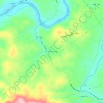
Name: Topografische Karte Barren Springs, Höhe, Relief.
Ort: Barren Springs, Wythe County, Virginia, 24313, United States (36.88818 -80.82063 36.92818 -80.78063)
Durchschnittliche Höhe: 642 m
Minimale Höhe: 564 m
Maximale Höhe: 784 m
Spenden
Rüsten Sie sich für Ihr nächstes Abenteuer:
Als Amazon-Partner erhält diese Website eine Provision für qualifizierte Käufe, ohne zusätzliche Kosten für Sie.
Andere topografische Karten
Klicken Sie auf eine Karte, um ihre Topografie, ihre Höhe und ihr Relief anzuzeigen.
Wytheville
United States > Virginia > Wythe County
Wytheville is nestled within the scenic Appalachian Mountains, characterized by a varied topography that features rolling hills, gentle valleys, and steep ridges. The town sits at an elevation of approximately 2,300 feet, which contributes to its cooler climate and offers picturesque views of the surrounding…
Durchschnittliche Höhe: 720 m
Spenden
Rüsten Sie sich für Ihr nächstes Abenteuer:
Als Amazon-Partner erhält diese Website eine Provision für qualifizierte Käufe, ohne zusätzliche Kosten für Sie.
Wytheville
United States > Virginia > Wythe County
Due to its elevation, the climate of Wytheville is either classified as mountain temperate or humid subtropical (Köppen Cfb or Cfa, respectively), and the town straddles the border between USDA Plant Hardiness Zones 6B and 7A. Summers are warm and humid, although significantly cooler than low-elevation places…
Durchschnittliche Höhe: 720 m