
Topografische Karte Paradise Island
Interaktive Karte
Klicken Sie auf die Karte, um die Höhe anzuzeigen.
Über diese Karte
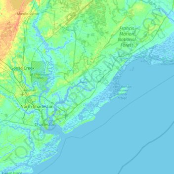
Name: Topografische Karte Paradise Island, Höhe, Relief.
Ort: Paradise Island, Charleston County, South Carolina, USA (32.60517 -80.07564 33.24517 -79.43564)
Durchschnittliche Höhe: 4 m
Minimale Höhe: -5 m
Maximale Höhe: 34 m
Andere topografische Karten
Klicken Sie auf eine Karte, um ihre Topografie, ihre Höhe und ihr Relief anzuzeigen.
Grenadier
USA > South Carolina > Grenadier
Grenadier, Lexington County, South Carolina, 29210, USA
Durchschnittliche Höhe: 74 m
Alligator Lake
USA > South Carolina > Alligator Lake
Alligator Lake, Florence County, South Carolina, 29504, USA
Durchschnittliche Höhe: 38 m
Tenmile
USA > South Carolina > Tenmile
Tenmile, Charleston County, South Carolina, 29416, USA
Durchschnittliche Höhe: 9 m
Simmonsville
USA > South Carolina > Simmonsville
Simmonsville, Georgetown County, South Carolina, USA
Durchschnittliche Höhe: 5 m
Cane Creek Watershed Site Seven
USA > South Carolina > Camp Creek
Cane Creek Watershed Site Seven, Home Place Lane, Camp Creek, Lancaster County, South Carolina, 29720, USA
Durchschnittliche Höhe: 174 m
Cape Romain National Wildlife Refuge
USA > South Carolina > Awendaw
Cape Romain National Wildlife Refuge, Awendaw, Charleston County, South Carolina, USA
Durchschnittliche Höhe: 3 m
Spartanburg
USA > South Carolina > Spartanburg
Spartanburg, Spartanburg County, South Carolina, USA
Durchschnittliche Höhe: 234 m