
Topografische Karte Fort Worth
Interaktive Karte
Klicken Sie auf die Karte, um die Höhe anzuzeigen.
Über diese Karte
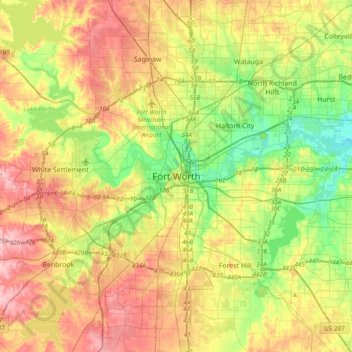
Name: Topografische Karte Fort Worth, Höhe, Relief.
Ort: Fort Worth, Tarrant County, Texas, 76102, United States (32.59318 -97.49275 32.91318 -97.17275)
Durchschnittliche Höhe: 202 m
Minimale Höhe: 139 m
Maximale Höhe: 279 m
Andere topografische Karten
Klicken Sie auf eine Karte, um ihre Topografie, ihre Höhe und ihr Relief anzuzeigen.
Moselle
United States > Texas > Tarrant County > Fort Worth
Moselle, Fort Worth, Tarrant County, Texas, 76134, United States
Durchschnittliche Höhe: 233 m
Rendon
United States > Texas > Tarrant County > Fort Worth
Rendon, Fort Worth, Tarrant County, Texas, United States
Durchschnittliche Höhe: 221 m
Glenwood Park
United States > Texas > Tarrant County > Fort Worth
Glenwood Park, Fort Worth, Tarrant County, Texas, 76104, United States
Durchschnittliche Höhe: 179 m
Ederville
United States > Texas > Tarrant County > Fort Worth > Ederville
Ederville, Fort Worth, Tarrant County, Texas, 76112, United States
Durchschnittliche Höhe: 187 m