
Topografische Karte Saitama
Interaktive Karte
Klicken Sie auf die Karte, um die Höhe anzuzeigen.
Über diese Karte
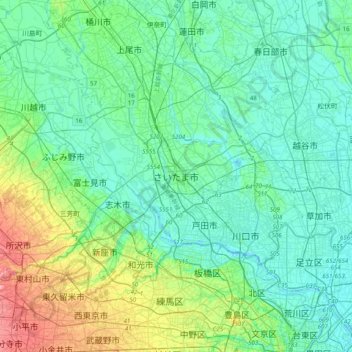
Name: Topografische Karte Saitama, Höhe, Relief.
Ort: Saitama, Saitama Prefecture, 3300061, Japan (35.70164 139.48580 36.02164 139.80580)
Durchschnittliche Höhe: 21 m
Minimale Höhe: -4 m
Maximale Höhe: 102 m
The city is located 20 to 30 km north of central Tokyo, roughly at the center of the Kantō Plain. Situated in the southeast of Saitama Prefecture, the city is topographically comprised by lowlands and plateaus, at mostly less than 20 m above sea level, with no mountain ranges or hills within the city boundaries. The western portion of the city lies on the lowland created by the Arakawa River along with those created by small rivers such as the Moto-Arakawa River, Shiba River, and Ayase River. The rest of the area mostly resides on the Ōmiya Plateau lying in the north-south direction. Dispersed in this region, major rivers flow southward, almost paralleling to one another.