
Topografische Karte Amaya Pampa
Interaktive Karte
Klicken Sie auf die Karte, um die Höhe anzuzeigen.
Über diese Karte
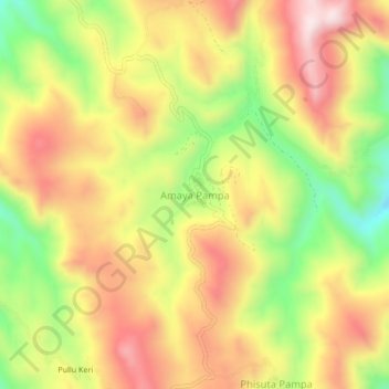
Name: Topografische Karte Amaya Pampa, Höhe, Relief.
Durchschnittliche Höhe: 4.046 m
Minimale Höhe: 3.784 m
Maximale Höhe: 4.271 m
Andere topografische Karten
Klicken Sie auf eine Karte, um ihre Topografie, ihre Höhe und ihr Relief anzuzeigen.
Chayanta
Bolivia > Potosí > Provincia Rafael Bustillo > Municipio Chayanta
Chayanta, Municipio Chayanta, Provincia Rafael Bustillo, Potosí, Bolivia
Durchschnittliche Höhe: 3.740 m