
Topografische Karte Collaroy
Interaktive Karte
Klicken Sie auf die Karte, um die Höhe anzuzeigen.
Über diese Karte
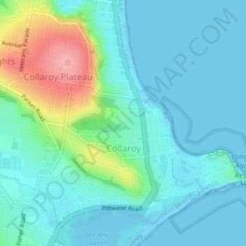
Name: Topografische Karte Collaroy, Höhe, Relief.
Durchschnittliche Höhe: 24 m
Minimale Höhe: -2 m
Maximale Höhe: 111 m
Andere topografische Karten
Klicken Sie auf eine Karte, um ihre Topografie, ihre Höhe und ihr Relief anzuzeigen.
Avalon Beach
Australien > Neusüdwales > Sydney
Avalon Beach, Northern Beaches, Sydney, Northern Beaches Council, Neusüdwales, 2107, Australien
Durchschnittliche Höhe: 23 m
Looking Glass Bay
Australien > Neusüdwales > Sydney
Looking Glass Bay, Sydney, Neusüdwales, 2111, Australien
Durchschnittliche Höhe: 15 m
Sutherland
Australien > Neusüdwales > Sydney
Sutherland, Sydney, Sutherland Shire Council, Neusüdwales, 2232, Australien
Durchschnittliche Höhe: 80 m
Eastern Suburbs
Australien > Neusüdwales > Sydney
Eastern Suburbs, Sydney, Randwick City Council, Neusüdwales, Australien
Durchschnittliche Höhe: 13 m
St Leonards
Australien > Neusüdwales > Sydney
St Leonards, Sydney, Willoughby City Council, Neusüdwales, 2065, Australien
Durchschnittliche Höhe: 69 m
Careening Cove
Australien > Neusüdwales > Sydney
Careening Cove, Sydney, Neusüdwales, 2061, Australien
Durchschnittliche Höhe: 25 m
Riverstone
Australien > Neusüdwales > Sydney
Riverstone, Sydney, Blacktown City Council, Neusüdwales, 2765, Australien
Durchschnittliche Höhe: 26 m
Sydney Water Supply Canal
Australien > Neusüdwales > Sydney
Sydney Water Supply Canal, Gilead, Sydney, Campbelltown City Council, Neusüdwales, 2560, Australien
Durchschnittliche Höhe: 133 m
Katoomba
Australien > Neusüdwales > Sydney
Katoomba, Sydney, Blue Mountains City Council, Neusüdwales, 2780, Australien
Durchschnittliche Höhe: 912 m
Padstow
Australien > Neusüdwales > Sydney
Padstow, Sydney, Canterbury-Bankstown Council, Neusüdwales, 2211, Australien
Durchschnittliche Höhe: 18 m
Sydney CBD
Australien > Neusüdwales > Sydney
Sydney CBD, Sydney, Neusüdwales, 2000, Australien
Durchschnittliche Höhe: 23 m
Pyrmont
Australien > Neusüdwales > Sydney
Pyrmont, Sydney, Council of the City of Sydney, Neusüdwales, 2009, Australien
Durchschnittliche Höhe: 18 m
Manly Vale
Australien > Neusüdwales > Sydney
Manly Vale, Northern Beaches, Sydney, Northern Beaches, Neusüdwales, 2093, Australien
Durchschnittliche Höhe: 34 m
Stanmore
Australien > Neusüdwales > Sydney
Stanmore, Sydney, Inner West, Neusüdwales, 2048, Australien
Durchschnittliche Höhe: 27 m
Mortdale
Australien > Neusüdwales > Sydney
Mortdale, St George, Sydney, Georges River, Neusüdwales, 2223, Australien
Durchschnittliche Höhe: 38 m
Yarrawarrah
Australien > Neusüdwales > Sydney
Yarrawarrah, Sydney, Sutherland, Neusüdwales, 2233, Australien
Durchschnittliche Höhe: 124 m
Engadine
Australien > Neusüdwales > Sydney
Engadine, Sydney, Sutherland Shire Council, Neusüdwales, 2233, Australien
Durchschnittliche Höhe: 121 m
Camperdown
Australien > Neusüdwales > Sydney
Camperdown, Inner West, Sydney, Council of the City of Sydney, Neusüdwales, 2050, Australien
Durchschnittliche Höhe: 26 m
Ryde
Australien > Neusüdwales > Sydney
Ryde, Sydney, Ryde, Neusüdwales, 2112, Australien
Durchschnittliche Höhe: 52 m