
Spenden
Rüsten Sie sich für Ihr nächstes Abenteuer:
Als Amazon-Partner erhält diese Website eine Provision für qualifizierte Käufe, ohne zusätzliche Kosten für Sie.
Topografische Karte Yugorsk
Klicken Sie auf die Karte, um die Höhe anzuzeigen.
Spenden
Rüsten Sie sich für Ihr nächstes Abenteuer:
Als Amazon-Partner erhält diese Website eine Provision für qualifizierte Käufe, ohne zusätzliche Kosten für Sie.
Über diese Karte
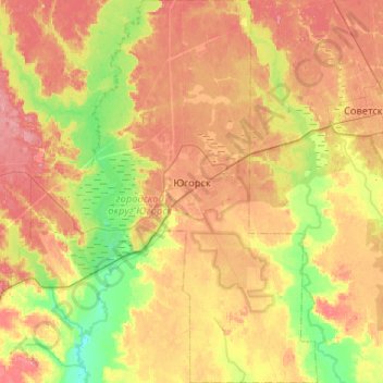
Name: Topografische Karte Yugorsk, Höhe, Relief.
Durchschnittliche Höhe: 103 m
Minimale Höhe: 62 m
Maximale Höhe: 144 m
Spenden
Rüsten Sie sich für Ihr nächstes Abenteuer:
Als Amazon-Partner erhält diese Website eine Provision für qualifizierte Käufe, ohne zusätzliche Kosten für Sie.
Andere topografische Karten
Klicken Sie auf eine Karte, um ihre Topografie, ihre Höhe und ihr Relief anzuzeigen.
Ural Mountains
Russia > Khanty-Mansiysk Autonomous Okrug – Ugra > Beryozovsky District
The Ural Mountains (/ˈjʊərəl/ YOOR-əl; Russian: Ура́льские го́ры, tr. Uralskiye gory, IPA: [ʊˈralʲskʲɪjə ˈɡorɨ]; Bashkir: Урал тауҙары) or simply the Urals, are a mountain range in Eurasia that runs north-south mostly through Russia, from the coast of the Arctic Ocean to…
Durchschnittliche Höhe: 1.435 m
Ural Mountains
Russia > Khanty-Mansiysk Autonomous Okrug – Ugra > Beryozovsky District
The Ural Mountains (/ˈjʊərəl/ YOOR-əl), or simply the Urals, are a mountain range in Eurasia that runs north–south mostly through Russia, from the coast of the Arctic Ocean to the river Ural and northwestern Kazakhstan. The mountain range forms part of the conventional boundary between the continents of…
Durchschnittliche Höhe: 1.435 m
Тюли
Russia > Khanty-Mansiysk Autonomous Okrug – Ugra > Khanty-Mansiysky District
Durchschnittliche Höhe: 27 m
Верхнеказымский
Russia > Khanty-Mansiysk Autonomous Okrug – Ugra > Beloyarsky District
Durchschnittliche Höhe: 40 m
Spenden
Rüsten Sie sich für Ihr nächstes Abenteuer:
Als Amazon-Partner erhält diese Website eine Provision für qualifizierte Käufe, ohne zusätzliche Kosten für Sie.
Mount Narodnaya
Russia > Khanty-Mansiysk Autonomous Okrug – Ugra > Beryozovsky District
Mount Narodnaya (also known as Naroda and Poenurr; Russian: гора Народная, Komi: Народа-Из ("People's Mountain"), Mansi: Поэӈ-ур, Поэн-урр) is the highest peak of the Urals in Russia. Its elevation is 1,894 metres (6,214 ft). It is located on the border between Khanty–Mansi…
Durchschnittliche Höhe: 1.437 m
Lokosovo
Russia > Khanty-Mansiysk Autonomous Okrug – Ugra > Surgutsky District
Durchschnittliche Höhe: 42 m
Fyodorovsky
Russia > Khanty-Mansiysk Autonomous Okrug – Ugra > Surgutsky District
Durchschnittliche Höhe: 65 m
West Siberian Plain
Russia > Khanty-Mansiysk Autonomous Okrug – Ugra > Nizhnevartovsky District
Durchschnittliche Höhe: 70 m
Spenden
Rüsten Sie sich für Ihr nächstes Abenteuer:
Als Amazon-Partner erhält diese Website eine Provision für qualifizierte Käufe, ohne zusätzliche Kosten für Sie.
Каюкова
Russia > Khanty-Mansiysk Autonomous Okrug – Ugra > Surgutsky District
Durchschnittliche Höhe: 48 m
Охтеурье
Russia > Khanty-Mansiysk Autonomous Okrug – Ugra > Nizhnevartovsky District
Durchschnittliche Höhe: 51 m
Сосновка
Russia > Khanty-Mansiysk Autonomous Okrug – Ugra > Beloyarsky District
Durchschnittliche Höhe: 100 m
Spenden
Rüsten Sie sich für Ihr nächstes Abenteuer:
Als Amazon-Partner erhält diese Website eine Provision für qualifizierte Käufe, ohne zusätzliche Kosten für Sie.
Chemashi
Russia > Khanty-Mansiysk Autonomous Okrug – Ugra > Oktyabrsky District
Durchschnittliche Höhe: 25 m
Шайтанка
Russia > Khanty-Mansiysk Autonomous Okrug – Ugra > Beryozovsky District > Beryozovo
Durchschnittliche Höhe: 24 m
Пырьях
Russia > Khanty-Mansiysk Autonomous Okrug – Ugra > Khanty-Mansiysky District
Durchschnittliche Höhe: 29 m
Хурумпауль
Russia > Khanty-Mansiysk Autonomous Okrug – Ugra > Beryozovsky District
Durchschnittliche Höhe: 21 m
Spenden
Rüsten Sie sich für Ihr nächstes Abenteuer:
Als Amazon-Partner erhält diese Website eine Provision für qualifizierte Käufe, ohne zusätzliche Kosten für Sie.
Ural Mountains
Russia > Khanty-Mansiysk Autonomous Okrug – Ugra > Beryozovsky District
As attested by Sigismund von Herberstein, in the 16th century Russians called the Ural range by a variety of names derived from the Russian words for rock (stone) and belt. The modern Russian name for the Urals (Урал, Ural), first appearing in the 16th–17th century during the Russian conquest of Siberia,…
Durchschnittliche Höhe: 1.435 m
Ural Mountains
Russia > Khanty-Mansiysk Autonomous Okrug – Ugra > Beryozovsky District
The Ural Mountains (/ˈjʊərəl/ YOOR-əl; Russian: Уральские горы, tr. Urál'skiye góry, IPA: [ʊˈralʲskʲɪjə ˈɡorɨ]), or simply the Urals, is a mountain range in Eurasia that runs north-south mostly through Russia, from the coast of the Arctic Ocean to the river Ural and northwestern…
Durchschnittliche Höhe: 1.435 m
Мозям
Russia > Khanty-Mansiysk Autonomous Okrug – Ugra > Beloyarsky District > Beloyarsky
Durchschnittliche Höhe: 41 m
Сохсъя
Russia > Khanty-Mansiysk Autonomous Okrug – Ugra > Beryozovsky District
Durchschnittliche Höhe: 30 m
Spenden
Rüsten Sie sich für Ihr nächstes Abenteuer:
Als Amazon-Partner erhält diese Website eine Provision für qualifizierte Käufe, ohne zusätzliche Kosten für Sie.
Khanty-Mansiysk
Russia > Khanty-Mansiysk Autonomous Okrug – Ugra > Khanty-Mansiysk Urban Okrug > Khanty-Mansiysk
Durchschnittliche Höhe: 29 m