
Topografische Karte Tours
Interaktive Karte
Klicken Sie auf die Karte, um die Höhe anzuzeigen.
Über diese Karte
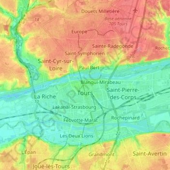
Name: Topografische Karte Tours, Höhe, Relief.
Durchschnittliche Höhe: 73 m
Minimale Höhe: 40 m
Maximale Höhe: 116 m
Tours a une altitude minimale de 44 m et une maximale de 109 m, son altitude moyenne est de 77 m tandis que celle de sa mairie est de 52 m environ.
Andere topografische Karten
Klicken Sie auf eine Karte, um ihre Topografie, ihre Höhe und ihr Relief anzuzeigen.
Les Champs Créteaux
France > Centre-Val de Loire > Indre-et-Loire > Restigné > Les Mesliers
Les Champs Créteaux, Les Mesliers, Restigné, Chinon, Indre-et-Loire, Centre-Val de Loire, France métropolitaine, 37140, France
Durchschnittliche Höhe: 37 m
La Cote Rotie
France > Centre-Val de Loire > Indre-et-Loire > Nazelles-Négron
La Cote Rotie, Nazelles-Négron, Loches, Indre-et-Loire, Centre-Val de Loire, France métropolitaine, 37530, France
Durchschnittliche Höhe: 76 m
Cravant-les-Côteaux
France > Centre-Val de Loire > Indre-et-Loire
Cravant-les-Côteaux, Chinon, Indre-et-Loire, Centre-Val de Loire, France métropolitaine, 37500, France
Durchschnittliche Höhe: 80 m
Mettray
France > Centre-Val de Loire > Indre-et-Loire
Mettray, Tours, Indre-et-Loire, Centre-Val de Loire, France métropolitaine, 37390, France
Durchschnittliche Höhe: 85 m
La Butte
France > Centre-Val de Loire > Indre-et-Loire > Rochecorbon
La Butte, Rochecorbon, Tours, Indre-et-Loire, Centre-Val de Loire, France métropolitaine, 37210, France
Durchschnittliche Höhe: 74 m
Touraine
France > Centre-Val de Loire > Indre-et-Loire > Ligré
Touraine, Ligré, Chinon, Indre-et-Loire, Centre-Val de Loire, France métropolitaine, 37500, France
Durchschnittliche Höhe: 72 m
La Saboterie
France > Centre-Val de Loire > Indre-et-Loire > Saint-Avertin
La Saboterie, Saint-Avertin, Arrondissement de Tours, Indre-et-Loire, Centre-Val de Loire, France métropolitaine, 37550, France
Durchschnittliche Höhe: 80 m
La Roche
France > Centre-Val de Loire > Indre-et-Loire > Chargé
La Roche, Chargé, Loches, Indre-et-Loire, Centre-Val de Loire, France métropolitaine, 37530, France
Durchschnittliche Höhe: 78 m
Rougemont
France > Centre-Val de Loire > Indre-et-Loire > Saint-Avertin > Rougemont
Rougemont, Saint-Avertin, Tours, Indre-et-Loire, Centre-Val de Loire, France métropolitaine, 37550, France
Durchschnittliche Höhe: 76 m