
Spenden
Rüsten Sie sich für Ihr nächstes Abenteuer:
Als Amazon-Partner erhält diese Website eine Provision für qualifizierte Käufe, ohne zusätzliche Kosten für Sie.
Topografische Karte Bumbungan River
Klicken Sie auf die Karte, um die Höhe anzuzeigen.
Spenden
Rüsten Sie sich für Ihr nächstes Abenteuer:
Als Amazon-Partner erhält diese Website eine Provision für qualifizierte Käufe, ohne zusätzliche Kosten für Sie.
Bumbungan River
The waterfalls for which the Bumbungan river is famous is the Magdapio Falls, a section of the river in the town of Cavinti where the river drops about 300 feet (91 m). Because the original boat ride to reach the falls starts in Pagsanjan, it became known as the Pagsanjan Falls. This round trip boat ride consists of a 5.1-kilometre (3.2 mi) trip to the falls in a Filipino banca (dugout canoe with newer ones made with fiberglass), guided by a set of boatmen positioned at each end of the boat, as visitors are taken upriver passing through the narrow Pagsanjan Gorge, which gradually increase in elevation to over hundreds of feet high. The gorge is lined with trees, ferns, overhanging vines, rocks and boulders where varieties of fauna like birds, dragonflies, lizards and monkeys can be observed. The return trip, called Shooting the rapids, is a faster downriver ride as the skilled boatmen maneuvers the banca, avoiding rocks, as it glides through the rapids.
Spenden
Rüsten Sie sich für Ihr nächstes Abenteuer:
Als Amazon-Partner erhält diese Website eine Provision für qualifizierte Käufe, ohne zusätzliche Kosten für Sie.
Über diese Karte
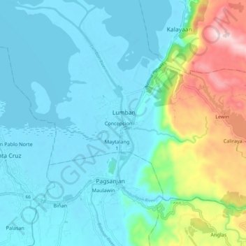
Name: Topografische Karte Bumbungan River, Höhe, Relief.
Durchschnittliche Höhe: 85 m
Minimale Höhe: -3 m
Maximale Höhe: 410 m
Spenden
Rüsten Sie sich für Ihr nächstes Abenteuer:
Als Amazon-Partner erhält diese Website eine Provision für qualifizierte Käufe, ohne zusätzliche Kosten für Sie.