Geolokalisieren

Topografische Karte Pauri Garhwal

Klicken Sie auf die Karte, um die Höhe anzuzeigen.

Pauri Garhwal

The mountains of Khirsu offer views of the northern Himalayas and attract a large number of tourists. Located 19 kilometres (12 mi) away from Pauri at an altitude of 1,700 metres (5,600 ft), Khirsu is peaceful and free from pollution. There is the nearby ancient temple of Ghandiyal Devta. Accommodation is available at the Tourist Rest House, Forest Rest House, and private hotel.

Wikipedia (CC-BY-SA 3.0)

Über diese Karte

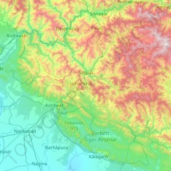
Name: Topografische Karte Pauri Garhwal, Höhe, Relief.

Ort: Pauri Garhwal, Uttarakhand, India (29.43426 78.20209 30.26025 79.23187)

Durchschnittliche Höhe: 958 m

Minimale Höhe: 226 m

Maximale Höhe: 3.068 m

Andere topografische Karten

Klicken Sie auf eine Karte, um ihre Topografie, ihre Höhe und ihr Relief anzuzeigen.

Dehradun

India > Uttarakhand > Dehradun

The city of Dehradun mainly lies in Doon Valley and is at a varying height from 410 m (1,350 ft) in Clement Town to above 700 m (2,300 ft) at Malsi which is 15 km (9.3 mi) from the city. However, the average elevation is 450 m (1,480 ft) above sea level. Malsi is the starting point of Lesser Himalayan Range…

Durchschnittliche Höhe: 904 m

Gopeshwar

India > Uttarakhand > Chamoli Tehsil

Gopeshwar is located at 30°25′N 79°20′E / 30.42°N 79.33°E / 30.42; 79.33. It has an average elevation of 1,450 m (4,760 ft). Gopeshwar is 8.4 km (5.2 mi) away from Chamoli which is located on the banks of Alaknanda river and along NH 58.

Durchschnittliche Höhe: 1.566 m

Rishikesh

India > Uttarakhand > Rishikesh

Rishikesh is at 30°06′12″N 78°17′41″E / 30.103368°N 78.294754°E / 30.103368; 78.294754. It has an average elevation of 372 metres (1,220 ft). The town is located in the Tehri Garhwal region of the northern Indian state of Uttarakhand.

Durchschnittliche Höhe: 497 m

Roorkee

India > Uttarakhand > Roorkee

Roorkee is located at 29°52′N 77°53′E / 29.87°N 77.88°E / 29.87; 77.88. It has an average elevation of 268 metres (879 ft).

Durchschnittliche Höhe: 270 m

Vielen Dank für die Unterstützung dieser Website ❤️
Spenden

Mussoorie

India > Uttarakhand > Dehradun

Mussoorie is at an average altitude of 2,005 metres (6,578 ft). To the northeast are the Himalayan snow ranges, and to the south, the Doon Valley and Shiwalik ranges. The second highest point is the original Lal Tibba in Landour, with a height of over 2,275 m (7,464 ft). Mussoorie is popularly known as The…

Durchschnittliche Höhe: 1.594 m

Kotdwar

India > Uttarakhand > Kotdwara

Kotdwar lies on the western margin of the Himalayas, at an altitude of 454 m (1,490 ft) above sea level.

Durchschnittliche Höhe: 471 m

Jainal

India > Uttarakhand > Bhikiasain

Durchschnittliche Höhe: 1.025 m

Garhwāl

India > Uttarakhand

Durchschnittliche Höhe: 2.621 m

Vielen Dank für die Unterstützung dieser Website ❤️
Spenden

Gaja

India > Uttarakhand > Narendra Nagar

Durchschnittliche Höhe: 1.599 m

Osla

India > Uttarakhand > Mori

Durchschnittliche Höhe: 3.157 m

Madesh

India > Uttarakhand > Rajgarhi > Hanuman Chatti

Durchschnittliche Höhe: 2.622 m

Dunagiri

India > Uttarakhand > Dwarahat

Durchschnittliche Höhe: 1.853 m

Vielen Dank für die Unterstützung dieser Website ❤️
Spenden

Rüsten Sie sich für Ihr nächstes Abenteuer:

Als Amazon-Partner erhält diese Website eine Provision für qualifizierte Käufe, ohne zusätzliche Kosten für Sie.

Bironkhal

India > Uttarakhand > Thailisain

Durchschnittliche Höhe: 1.439 m

Padampur Padlia

India > Uttarakhand > Haldwani > Lamachaur

Durchschnittliche Höhe: 338 m

asarkot

India > Uttarakhand > Chaubatta Khal > luntha

Durchschnittliche Höhe: 1.458 m

kameri

India > Uttarakhand > Chaubatta Khal > Sediyakhal

Durchschnittliche Höhe: 1.400 m

Maithan

India > Uttarakhand > Gairsain

Durchschnittliche Höhe: 1.414 m

Kirtinagar

India > Uttarakhand > Devprayag

Durchschnittliche Höhe: 708 m

Pothibasa Chatti

India > Uttarakhand > Ukhimath > Tala

Durchschnittliche Höhe: 2.212 m

Chakrata

India > Uttarakhand > Chakrata

It lies between the Tons and Yamuna rivers, at an elevation of 2118 m, 98 km from the state capital, Dehradun. Chakrata was originally a cantonment of the British Indian Army. To the west lies Shillai, Himachal Pradesh, and to the east are Mussoorie (73 km) and Tehri Garhwal.

Durchschnittliche Höhe: 1.851 m

Clement Town

India > Uttarakhand > Dehradun > Dehradun

Clement Town has an average elevation of 410 metres (1,350 ft).

Durchschnittliche Höhe: 610 m

Kamet

India > Uttarakhand > Joshimath Tehsil

Durchschnittliche Höhe: 6.701 m

Trisul I

India > Uttarakhand > Joshimath Tehsil

Durchschnittliche Höhe: 6.343 m

Sagar

India > Uttarakhand > Chamoli Tehsil > Gangalgaon

Durchschnittliche Höhe: 1.953 m

Dhārchula

India > Uttarakhand > Dharchula Tehsil

Durchschnittliche Höhe: 1.579 m

Pangarchulla

India > Uttarakhand > Joshimath Tehsil

Durchschnittliche Höhe: 4.061 m

Ekeshwar

India > Uttarakhand > Chaubatta Khal

Durchschnittliche Höhe: 1.469 m

Mewār

India > Uttarakhand > Lansdowne > Parshulikhal

Durchschnittliche Höhe: 1.246 m

takula

India > Uttarakhand > Almora

Durchschnittliche Höhe: 1.589 m

Lalpur

India > Uttarakhand > Kichha

Durchschnittliche Höhe: 208 m

Dhulai

India > Uttarakhand > Nainital > Ghorakhal

Durchschnittliche Höhe: 1.615 m

pakhri

India > Uttarakhand > Ranikhet

Durchschnittliche Höhe: 1.185 m

Nainital

India > Uttarakhand > Nainital

The city of Nainital covers a total area of 11.73 km2 (4.53 sq mi), and is located at 29°23′N 79°27′E / 29.38°N 79.45°E / 29.38; 79.45, at an average elevation of 2,084 metres (6,837 ft) above sea level. The slopes of the nearby mountains are most populated, with an elevation ranging from…

Durchschnittliche Höhe: 1.813 m

Ranchula

India > Uttarakhand > Yamkeshwar > Thunda

Durchschnittliche Höhe: 1.025 m

Tehri-Garhwal

India > Uttarakhand

Durchschnittliche Höhe: 2.339 m

Kaljikhal

India > Uttarakhand > Pauri

Durchschnittliche Höhe: 1.657 m

Mangraun

India > Uttarakhand > Thailisain > Jogimandi

Durchschnittliche Höhe: 1.755 m

Kasar Devi

India > Uttarakhand > Almora

Durchschnittliche Höhe: 1.547 m

Chhota Kailash

India > Uttarakhand > Nainital

Durchschnittliche Höhe: 1.197 m

Lal Tibba

India > Uttarakhand > Dehradun > Jabarkhet > batagad

Durchschnittliche Höhe: 1.872 m

Vielen Dank für die Unterstützung dieser Website ❤️
Spenden

Rüsten Sie sich für Ihr nächstes Abenteuer:

Als Amazon-Partner erhält diese Website eine Provision für qualifizierte Käufe, ohne zusätzliche Kosten für Sie.

pInola talla

India > Uttarakhand > Tehri > Pipli

Durchschnittliche Höhe: 1.281 m

charlevila

India > Uttarakhand > Dehradun

Durchschnittliche Höhe: 1.741 m

Gadsari

India > Uttarakhand > Thailisain

Durchschnittliche Höhe: 1.682 m

Jageshwar

India > Uttarakhand > Bhanoli

Durchschnittliche Höhe: 1.976 m

Vielen Dank für die Unterstützung dieser Website ❤️
Spenden

Lamgara

India > Uttarakhand > Lamgara Tehsil

Durchschnittliche Höhe: 1.770 m

Karnaprayag

India > Uttarakhand > Karnaprayag

Karnaprayag is located at 30°16′N 79°15′E / 30.27°N 79.25°E / 30.27; 79.25. It has an average elevation of 860 metres (2,820 feet). The confluence of the Pindar River, which arises from the icy Pindari glacier and the Alaknanda, occurs at Karnaprayag.

Durchschnittliche Höhe: 1.273 m

dwara

India > Uttarakhand > Dehradun > Dehradun

Durchschnittliche Höhe: 868 m

anjanisain

India > Uttarakhand > Jakhani Dhar

Durchschnittliche Höhe: 1.649 m

Vielen Dank für die Unterstützung dieser Website ❤️
Spenden

Rüsten Sie sich für Ihr nächstes Abenteuer:

Als Amazon-Partner erhält diese Website eine Provision für qualifizierte Käufe, ohne zusätzliche Kosten für Sie.

Harda Tadiyal

India > Uttarakhand > Molekhal > Harara

Durchschnittliche Höhe: 1.039 m

Mastari

India > Uttarakhand > Bhatwari > Thalan

Durchschnittliche Höhe: 1.646 m

Silogi

India > Uttarakhand > Lansdowne

Durchschnittliche Höhe: 1.481 m

Urgam

India > Uttarakhand > Joshimath Tehsil

Durchschnittliche Höhe: 2.351 m

Gulabrai

India > Uttarakhand > Rudraprayag

Durchschnittliche Höhe: 948 m

kaintholi

India > Uttarakhand > Jakhani Dhar > anjanisain

Durchschnittliche Höhe: 1.691 m

Sangliya

India > Uttarakhand > Dhoomakot

Durchschnittliche Höhe: 1.507 m

Bhurabagi

India > Uttarakhand > Tehri > New Tehri

Durchschnittliche Höhe: 1.625 m

Moila Top

India > Uttarakhand > Tyuni

Durchschnittliche Höhe: 2.368 m

mauna

India > Uttarakhand > Kosya Kutauli > chapar

Durchschnittliche Höhe: 1.416 m

Ghatna

India > Uttarakhand > Ukhimath

Durchschnittliche Höhe: 1.525 m

Gairsain

India > Uttarakhand > Gairsain

Durchschnittliche Höhe: 1.980 m

siyona

India > Uttarakhand > Almora > Katarmal

Durchschnittliche Höhe: 1.320 m

Chaundi

India > Uttarakhand > Thailisain > Khawasi

Durchschnittliche Höhe: 1.580 m

Tarakund

India > Uttarakhand > Thailisain

Durchschnittliche Höhe: 2.127 m

Telpura

India > Uttarakhand > Dehradun > Dehradun

Durchschnittliche Höhe: 614 m

Vielen Dank für die Unterstützung dieser Website ❤️
Spenden

Rüsten Sie sich für Ihr nächstes Abenteuer:

Als Amazon-Partner erhält diese Website eine Provision für qualifizierte Käufe, ohne zusätzliche Kosten für Sie.

Katarmal

India > Uttarakhand > Almora

Durchschnittliche Höhe: 1.270 m

laluri

India > Uttarakhand > Chaukhutiya

Durchschnittliche Höhe: 1.192 m

Mal Bajwar

India > Uttarakhand > Tharali

Durchschnittliche Höhe: 1.632 m

Nona Thach

India > Uttarakhand > Tyuni

Durchschnittliche Höhe: 2.123 m

Vielen Dank für die Unterstützung dieser Website ❤️
Spenden

Sankri

India > Uttarakhand > Mori

Durchschnittliche Höhe: 2.047 m

Sangila

India > Uttarakhand > Kosya Kutauli > Suralgaon

Durchschnittliche Höhe: 1.680 m

Namik

India > Uttarakhand > Munsiari tehsil

Durchschnittliche Höhe: 2.370 m

Milam Glacier

India > Uttarakhand > Munsiari tehsil

Milam Glacier, covering around 37 km2 (14 sq mi) area of 16 km (10 mi) length, is located about 15 kilometres (9 mi) northeast of Nanda Devi. It ranges in elevation from about 5,500 metres (18,000 ft) to about 3,870 metres (12,700 ft) at its snout. Situated on the south facing slope of the main Great Himalayas…

Durchschnittliche Höhe: 5.229 m

Vielen Dank für die Unterstützung dieser Website ❤️
Spenden

Rüsten Sie sich für Ihr nächstes Abenteuer:

Als Amazon-Partner erhält diese Website eine Provision für qualifizierte Käufe, ohne zusätzliche Kosten für Sie.

Lansdowne

India > Uttarakhand > Lansdowne

Lansdowne is a quaint hill station in the Pauri Garhwal district of Uttarakhand, India. Lodged in the picturesque surroundings of the Himalayan ranges, it lies at an elevation of approximately 1,700 meters (5,577 feet) above sea level. The town is about 45 kilometers (28 miles) from the district headquarters,…

Durchschnittliche Höhe: 1.140 m

Ketūkhāl

India > Uttarakhand > Lansdowne > Kirthikhal

Durchschnittliche Höhe: 1.418 m

Surmoli

India > Uttarakhand > Syalde > Deghat

Durchschnittliche Höhe: 1.154 m

Dhikala

India > Uttarakhand > Kotdwara

Durchschnittliche Höhe: 381 m

Bajan

India > Uttarakhand > Ramnagar > Patkot

Durchschnittliche Höhe: 694 m

thapla

India > Uttarakhand > Almora

Durchschnittliche Höhe: 1.642 m

khetu

India > Uttarakhand > Dhanaulti

Durchschnittliche Höhe: 1.401 m

kurai gad

India > Uttarakhand > Almora > naugaon

Durchschnittliche Höhe: 1.349 m

Vielen Dank für die Unterstützung dieser Website ❤️
Spenden

Pari Maatri Taal

India > Uttarakhand > Bhatwari

Durchschnittliche Höhe: 4.443 m

Parsoli Malli

India > Uttarakhand > Dhoomakot > Golikhal

Durchschnittliche Höhe: 1.049 m

Haldukhal

India > Uttarakhand > Dhoomakot

Durchschnittliche Höhe: 1.082 m

Karti

India > Uttarakhand > Lansdowne

Durchschnittliche Höhe: 1.487 m

Vielen Dank für die Unterstützung dieser Website ❤️
Spenden

Lālsānga

India > Uttarakhand > Chamoli Tehsil > Gopeshwar

Durchschnittliche Höhe: 1.360 m

Khati

India > Uttarakhand > Kapkot

Durchschnittliche Höhe: 2.392 m

Kumaon

India > Uttarakhand > Kosya Kutauli > Rāmgarh

Durchschnittliche Höhe: 1.968 m

Kandikhal(001)

India > Uttarakhand > Dhanaulti > Bhedryana

Durchschnittliche Höhe: 1.168 m

Jawaharna

India > Uttarakhand > Tehri

Durchschnittliche Höhe: 2.181 m

Gomukh, Ice Cave

India > Uttarakhand > Bhatwari

Around the snout, nature presents a wild topography. There are boulders scattered here and there with some pieces of broken snow, along with the hard clayey snow of the glacier.

Durchschnittliche Höhe: 4.286 m

Chopta

India > Uttarakhand > Tharali

Durchschnittliche Höhe: 1.427 m

Srinagar

India > Uttarakhand > Srinagar

Srinagar is located at 30°13′N 78°47′E / 30.22°N 78.78°E / 30.22; 78.78. at the left bank of Alaknanda river. It has an average elevation of 560 metres (1,837 feet). It is the largest town in the Garhwal Hills. It is reached by national highway NH58 from Rishikesh, Srinagar is about 104 km…

Durchschnittliche Höhe: 859 m

Vielen Dank für die Unterstützung dieser Website ❤️
Spenden

Lamgara

India > Uttarakhand > Lamgara Tehsil

Durchschnittliche Höhe: 1.758 m

Kothila

India > Uttarakhand > Thailisain

Durchschnittliche Höhe: 1.514 m

Chandrapuri (001)

India > Uttarakhand > Ukhimath

Durchschnittliche Höhe: 1.163 m

Tipola

India > Uttarakhand > Ranikhet

Durchschnittliche Höhe: 1.070 m

Pithoragarh

India > Uttarakhand > Pithoragarh Tehsil

Pithoragarh is located at 29°35′N 80°13′E / 29.58°N 80.22°E / 29.58; 80.22. in the district of Pithoragarh, Uttarakhand, India. It lies in the revenue Division of Kumaon and is located 188 km northeast of Nainital, the administrative headquarters of Kumaon. It has an average elevation of 1,627…

Durchschnittliche Höhe: 1.617 m

Kharadi

India > Uttarakhand > Rajgarhi

Durchschnittliche Höhe: 1.628 m

Than

India > Uttarakhand > Rajgarhi > Nagangaon

Durchschnittliche Höhe: 1.580 m

Lakshmeshwar

India > Uttarakhand > Thailisain > Bhagwali Taliya

Durchschnittliche Höhe: 1.656 m

Rüsten Sie sich für Ihr nächstes Abenteuer:

Sportuhren mit Topo-Karten - High-End Multisportuhren mit integrierter Kartendarstellung
🌞Solar Zeltbeleuchtung - Umweltfreundliche Lichtquelle fürs Camp
💡Mini Solarlampe - Kompakte Solar­leuchte für Outdoor
🎒Trekkingrucksack 70L - Großer Rucksack für Mehrtagestouren mit Kartenfach
🔭Wasserdichte Ferngläser - Ideal für die Orientierung an Seen und Küsten

Als Amazon-Partner erhält diese Website eine Provision für qualifizierte Käufe, ohne zusätzliche Kosten für Sie.