
Topografische Karte Ravenshead
Interaktive Karte
Klicken Sie auf die Karte, um die Höhe anzuzeigen.
Über diese Karte
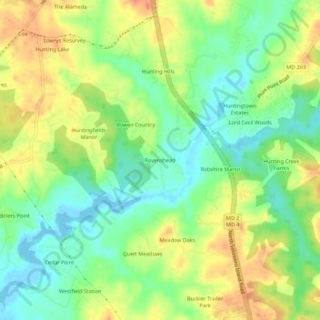
Name: Topografische Karte Ravenshead, Höhe, Relief.
Ort: Ravenshead, Calvert County, Maryland, 20610, United States (38.56095 -76.63357 38.60095 -76.59357)
Durchschnittliche Höhe: 22 m
Minimale Höhe: -4 m
Maximale Höhe: 47 m
Andere topografische Karten
Klicken Sie auf eine Karte, um ihre Topografie, ihre Höhe und ihr Relief anzuzeigen.
Queensberry
United States > Maryland > Calvert County > Prince Frederick
Queensberry, Prince Frederick, Calvert County, Maryland, 20678, United States
Durchschnittliche Höhe: 37 m
Calvert Cliffs
United States > Maryland > Calvert County
Calvert Cliffs, Calvert County, Maryland, 20657, United States
Durchschnittliche Höhe: 11 m
Lusby
United States > Maryland > Calvert County
Lusby, Calvert County, Maryland, United States
Durchschnittliche Höhe: 26 m
Lusby
United States > Maryland > Calvert County
Lusby, Calvert County, Maryland, 20657, United States
Durchschnittliche Höhe: 25 m
Solomons
United States > Maryland > Calvert County
Solomons, Calvert County, Maryland, 20688, United States
Durchschnittliche Höhe: 9 m
Mutual Consent
United States > Maryland > Calvert County > Mutual Consent
Mutual Consent, Calvert County, Maryland, 20676, United States
Durchschnittliche Höhe: 32 m
Solomons
United States > Maryland > Calvert County > Solomons
Solomons, Calvert County, Maryland, United States
Durchschnittliche Höhe: 4 m