
Topografische Karte Sidon
Interaktive Karte
Klicken Sie auf die Karte, um die Höhe anzuzeigen.
Sidon
The city of Sidon is administrated by the Municipality of Sidon. The municipality is constituted of a council of 21 members including the City Mayor and his Deputy. It has administrative and financial independence but remains under the control and supervision of the central government, specifically the Ministry of Interior. The municipality's jurisdiction is limited to a region of 786 hectares in area and 5 meters in elevation, while each of the city's suburbs is administrated by its own independent municipal council. Sidon is the center of the Governorate of South Lebanon, and hosts the seat of the Governor of Southern Lebanon. The city is also the center of the Sidon District and the Union of Sidon and Zahrani Municipalities (founded in 1978 and contains 15 municipalities). Sidon hosts the southern regional headquarters of a series of governmental facilities like the Central Bank of Lebanon, Électricité du Liban, Central Telecommunications Station and others. It is also the home of the Justice Palace of South Lebanon in its new headquarters on East Boulevard (the old headquarters were an old Ottoman Saray that is currently occupied by the LSF and is planned to be transformed into a cultural center by the municipality).[citation needed]
Über diese Karte
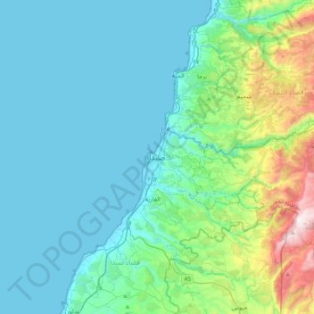
Name: Topografische Karte Sidon, Höhe, Relief.
Durchschnittliche Höhe: 230 m
Minimale Höhe: 0 m
Maximale Höhe: 1.407 m
Andere topografische Karten
Klicken Sie auf eine Karte, um ihre Topografie, ihre Höhe und ihr Relief anzuzeigen.