
Topografische Karte Montespluga
Interaktive Karte
Klicken Sie auf die Karte, um die Höhe anzuzeigen.
Über diese Karte
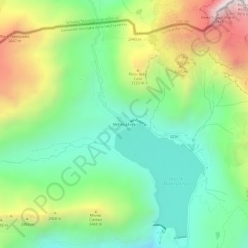
Name: Topografische Karte Montespluga, Höhe, Relief.
Durchschnittliche Höhe: 2.194 m
Minimale Höhe: 1.748 m
Maximale Höhe: 2.997 m
Montespluga is an Alpine village near the head of the Valle Spluga in the Italian region of Lombardy. It is a frazione of the comune of Madesimo, located at 1,908 m of altitude on the road to Chiavenna.