
Topografische Karte Strathpeffer
Interaktive Karte
Klicken Sie auf die Karte, um die Höhe anzuzeigen.
Über diese Karte
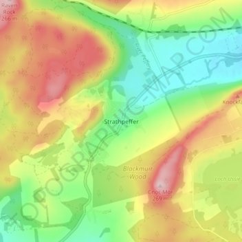
Name: Topografische Karte Strathpeffer, Höhe, Relief.
Ort: Strathpeffer, Highland, Scotland, IV14 9DW, United Kingdom (57.56801 -4.55819 57.60801 -4.51819)
Durchschnittliche Höhe: 127 m
Minimale Höhe: 18 m
Maximale Höhe: 262 m
It lies in a strath 5 miles (8 km) west of Dingwall, with the elevation ranging from 60 to 120 m (200 to 400 ft) above sea level. Sheltered on the west and north, it has a comparatively dry and warm climate.
Andere topografische Karten
Klicken Sie auf eine Karte, um ihre Topografie, ihre Höhe und ihr Relief anzuzeigen.
Rosemarkie
United Kingdom > Scotland > Highland
Rosemarkie, Highland, Scotland, IV10 8UJ, United Kingdom
Durchschnittliche Höhe: 44 m
Achintee
United Kingdom > Scotland > Highland > Glen Nevis
Achintee, Glen Nevis, Highland, Scotland, PH33 6TE, United Kingdom
Durchschnittliche Höhe: 214 m
Dores
United Kingdom > Scotland > Highland
Dores, Highland, Scotland, IV2 6TT, United Kingdom
Durchschnittliche Höhe: 106 m
Drumchork
United Kingdom > Scotland > Highland > Aultbea
Drumchork, Aultbea, Highland, Scotland, IV22 2HU, United Kingdom
Durchschnittliche Höhe: 50 m
Kilmore
United Kingdom > Scotland > Highland > Ferindonald
Kilmore, Sleat, Ferindonald, Highland, Scotland, IV44 8RG, United Kingdom
Durchschnittliche Höhe: 61 m
Scottish Highlands
United Kingdom > Scotland > Highland
Scottish Highlands, Highland, Scotland, United Kingdom
Durchschnittliche Höhe: 907 m
Inverness
United Kingdom > Scotland > Highland
Inverness, Highland, Scotland, IV1 1AN, United Kingdom
Durchschnittliche Höhe: 163 m
Grampian Mountains
United Kingdom > Scotland > Highland
Grampian Mountains, Highland, Scotland, United Kingdom
Durchschnittliche Höhe: 775 m
Ben Nevis
United Kingdom > Scotland > Highland
Ben Nevis, Highland, Scotland, United Kingdom
Durchschnittliche Höhe: 912 m