
Topografische Karte Belfast
Interaktive Karte
Klicken Sie auf die Karte, um die Höhe anzuzeigen.
Über diese Karte
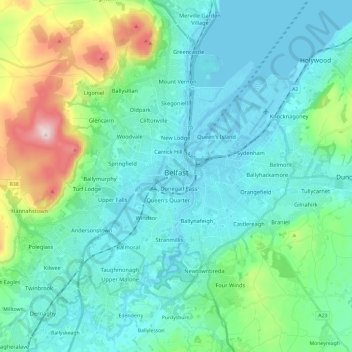
Name: Topografische Karte Belfast, Höhe, Relief.
Ort: Belfast, County Antrim, Northern Ireland, United Kingdom (54.53061 -6.04548 54.65942 -5.80769)
Durchschnittliche Höhe: 92 m
Minimale Höhe: -2 m
Maximale Höhe: 476 m
Andere topografische Karten
Klicken Sie auf eine Karte, um ihre Topografie, ihre Höhe und ihr Relief anzuzeigen.
Cave Hill
United Kingdom > Northern Ireland > County Antrim > Belfast
Cave Hill, Greencastle, Belfast, County Antrim, Northern Ireland, BT15 5GL, United Kingdom
Durchschnittliche Höhe: 172 m
Giant's Causeway
United Kingdom > Northern Ireland > County Antrim
Giant's Causeway, County Antrim, Ulster, Northern Ireland, United Kingdom
Durchschnittliche Höhe: 26 m
Ahoghill
United Kingdom > Northern Ireland > County Antrim
Ahoghill, County Antrim, Ulster, Northern Ireland, BT42 1JZ, United Kingdom
Durchschnittliche Höhe: 84 m
Upper Ballysillan
United Kingdom > Northern Ireland > County Antrim
Upper Ballysillan, County Antrim, Northern Ireland, United Kingdom
Durchschnittliche Höhe: 254 m
Glynn
United Kingdom > Northern Ireland > County Antrim > Glynn
Glynn, County Antrim, Northern Ireland, BT40 3HF, United Kingdom
Durchschnittliche Höhe: 63 m
Larne
United Kingdom > Northern Ireland > County Antrim > Larne
Larne, County Antrim, Northern Ireland, BT40 1HU, United Kingdom
Durchschnittliche Höhe: 54 m
Belfast
United Kingdom > Northern Ireland > County Antrim
Belfast, County Antrim, Ulster, Northern Ireland, BT1 5GS, United Kingdom
Durchschnittliche Höhe: 87 m
Lisburn
United Kingdom > Northern Ireland > County Antrim
Lisburn, County Antrim, Northern Ireland, BT28 1BJ, United Kingdom
Durchschnittliche Höhe: 92 m