
Spenden
Rüsten Sie sich für Ihr nächstes Abenteuer:
Als Amazon-Partner erhält diese Website eine Provision für qualifizierte Käufe, ohne zusätzliche Kosten für Sie.
Topografische Karte Miyako
Klicken Sie auf die Karte, um die Höhe anzuzeigen.
Spenden
Rüsten Sie sich für Ihr nächstes Abenteuer:
Als Amazon-Partner erhält diese Website eine Provision für qualifizierte Käufe, ohne zusätzliche Kosten für Sie.
Über diese Karte
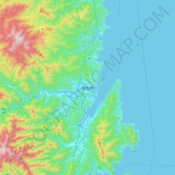
Name: Topografische Karte Miyako, Höhe, Relief.
Ort: Miyako, Iwate Prefecture, Japan (39.47958 141.78612 39.79958 142.10612)
Durchschnittliche Höhe: 223 m
Minimale Höhe: -1 m
Maximale Höhe: 1.214 m
Spenden
Rüsten Sie sich für Ihr nächstes Abenteuer:
Als Amazon-Partner erhält diese Website eine Provision für qualifizierte Käufe, ohne zusätzliche Kosten für Sie.
Andere topografische Karten
Klicken Sie auf eine Karte, um ihre Topografie, ihre Höhe und ihr Relief anzuzeigen.
Tokyo
The mainland portion of Tokyo lies northwest of Tokyo Bay and measures about 90 km (56 mi) east to west and 25 km (16 mi) north to south. The average elevation in Tokyo is 40 m (131 ft). Chiba Prefecture borders it to the east, Yamanashi to the west, Kanagawa to the south, and Saitama to the north. Mainland…
Durchschnittliche Höhe: 22 m
Spenden
Rüsten Sie sich für Ihr nächstes Abenteuer:
Als Amazon-Partner erhält diese Website eine Provision für qualifizierte Käufe, ohne zusätzliche Kosten für Sie.
Tokyo Bay
The shoal between Cape Futtsu in Chiba Prefecture and Cape Honmaku in Yokohama is known as Nakanose, and has a depth of 20 m (66 ft). North of this area the bay has a depth of 40 m (130 ft) and an uncomplicated underwater topography. Areas south of Nakanose are significantly deeper moving towards the Pacific…
Durchschnittliche Höhe: 19 m
Nagasaki
On the day of the nuclear strike (August 9, 1945) the population in Nagasaki was estimated to be 263,000, which consisted of 240,000 Japanese residents, 10,000 Korean residents, 2,500 conscripted Korean workers, 9,000 Japanese soldiers, 600 conscripted Chinese workers, and 400 Allied POWs. That day, the Boeing…
Durchschnittliche Höhe: 44 m
Hokkaido
As Japan's coldest region, Hokkaidō has relatively cool summers and icy/snowy winters. Most of the island falls in the humid continental climate zone with Köppen climate classification Dfb (hemiboreal) in most areas but Dfa (hot summer humid continental) in some inland lowlands. The average August…
Durchschnittliche Höhe: 98 m
Spenden
Rüsten Sie sich für Ihr nächstes Abenteuer:
Als Amazon-Partner erhält diese Website eine Provision für qualifizierte Käufe, ohne zusätzliche Kosten für Sie.
Sendai
Sendai is located at lat. 38°16'05" north, long. 140°52'11" east. The city's area is 788.09 km2 (304.28 sq mi), and stretches from the Pacific Ocean to the Ōu Mountains, which are the east and west borders of Miyagi Prefecture. As a result, the city's geography is quite diverse. Eastern Sendai is a plains…
Durchschnittliche Höhe: 185 m
Spenden
Rüsten Sie sich für Ihr nächstes Abenteuer:
Als Amazon-Partner erhält diese Website eine Provision für qualifizierte Käufe, ohne zusätzliche Kosten für Sie.
Yokohama
Yokohama has a total area of 437.38 km2 (168.87 sq mi) at an elevation of 5 metres (16 ft) above sea level. It is the capital of Kanagawa Prefecture, bordered to the east by Tokyo Bay and located in the middle of the Kantō plain. The city is surrounded by hills and the characteristic mountain system of the…
Durchschnittliche Höhe: 23 m
Spenden
Rüsten Sie sich für Ihr nächstes Abenteuer:
Als Amazon-Partner erhält diese Website eine Provision für qualifizierte Käufe, ohne zusätzliche Kosten für Sie.
Tokyo
The mainland portion of Tokyo lies northwest of Tokyo Bay and measures about 90 km (56 mi) east to west and 25 km (16 mi) north to south. The average elevation in Tokyo is 40 m (131 ft). Chiba Prefecture borders it to the east, Yamanashi to the west, Kanagawa to the south, and Saitama to the north. Mainland…
Durchschnittliche Höhe: 22 m
Spenden
Rüsten Sie sich für Ihr nächstes Abenteuer:
Als Amazon-Partner erhält diese Website eine Provision für qualifizierte Käufe, ohne zusätzliche Kosten für Sie.
Tokyo
The mainland portion of Tokyo lies northwest of Tokyo Bay and measures about 90 km (56 mi) east to west and 25 km (16 mi) north to south. The average elevation in Tokyo is 40 m (131 ft). Chiba Prefecture borders it to the east, Yamanashi to the west, Kanagawa to the south, and Saitama to the north. Mainland…
Durchschnittliche Höhe: 22 m
Kamakura
The Kamakura shogunate era is called by historians the Kamakura period and, although its end is clearly set (Siege of Kamakura (1333)), its beginning is not. Different historians put Kamakura's beginning at a different point in time within a range that goes from the establishment of Yoritomo's first military…
Durchschnittliche Höhe: 33 m
Spenden
Rüsten Sie sich für Ihr nächstes Abenteuer:
Als Amazon-Partner erhält diese Website eine Provision für qualifizierte Käufe, ohne zusätzliche Kosten für Sie.
Tokyo
The mainland portion of Tokyo lies northwest of Tokyo Bay and measures about 90 km (56 mi) east to west and 25 km (16 mi) north to south. The average elevation in Tokyo is 40 m (131 ft). Chiba Prefecture borders it to the east, Yamanashi to the west, Kanagawa to the south, and Saitama to the north. Mainland…
Durchschnittliche Höhe: 22 m
Spenden
Rüsten Sie sich für Ihr nächstes Abenteuer:
Als Amazon-Partner erhält diese Website eine Provision für qualifizierte Käufe, ohne zusätzliche Kosten für Sie.
Nagano
Nagano (長野市, Nagano-shi, pronounced [nagaꜜno ɕi]) is the capital and largest city of Nagano Prefecture, located in the Nagano Basin (Zenkoji Daira) in the central Chūbu region of Japan. Nagano is categorized as a core city of Japan. Nagano City is the highest prefectural capital in Japan, with an…
Durchschnittliche Höhe: 828 m
Spenden
Rüsten Sie sich für Ihr nächstes Abenteuer:
Als Amazon-Partner erhält diese Website eine Provision für qualifizierte Käufe, ohne zusätzliche Kosten für Sie.
Sapporo
Sapporo is a city located in the southwest part of Ishikari Plain and the alluvial fan of the Toyohira River, a tributary stream of the Ishikari River. It is part of Ishikari Subprefecture. Roadways in the urban district are laid to make a grid plan. The western and southern parts of Sapporo are occupied by a…
Durchschnittliche Höhe: 273 m
Hakone
Hakone is characterized by its rugged topography, featuring a mix of mountainous terrain, valleys, and volcanic landscapes. Nestled within the greater Fuji-Hakone-Izu National Park, Hakone's elevation varies dramatically, with peaks rising over 4,000 feet and low-lying areas near Lake Ashi, which sits at…
Durchschnittliche Höhe: 722 m
Spenden
Rüsten Sie sich für Ihr nächstes Abenteuer:
Als Amazon-Partner erhält diese Website eine Provision für qualifizierte Käufe, ohne zusätzliche Kosten für Sie.
Sapporo
Sapporo is a city located in the southwest part of Ishikari Plain and the alluvial fan of the Toyohira River, a tributary stream of the Ishikari River. It is part of Ishikari Subprefecture. Roadways in the urban district are laid to make a grid plan. The western and southern parts of Sapporo are occupied by a…
Durchschnittliche Höhe: 273 m
Spenden
Rüsten Sie sich für Ihr nächstes Abenteuer:
Als Amazon-Partner erhält diese Website eine Provision für qualifizierte Käufe, ohne zusätzliche Kosten für Sie.
Shinjuku
Naturally, most of Shinjuku is occupied by the Yodobashi Plateau, the most elevated portion of which extends through most of the Shinjuku Station area. The Kanda River runs through the Ochiai and Totsuka areas near sea level, but the Toshima Plateau also builds elevation in the northern extremities of Totsuka…
Durchschnittliche Höhe: 35 m
Spenden
Rüsten Sie sich für Ihr nächstes Abenteuer:
Als Amazon-Partner erhält diese Website eine Provision für qualifizierte Käufe, ohne zusätzliche Kosten für Sie.
Hitoyoshi
Hitoyoshi is located about 70 kilometers due south of the prefectural capital of Kumamoto City in a straight line and is the southernmost part of Kumamoto Prefecture. The northern and southern parts of the city are mountainous, forming part of the Kyushu Mountains. The southern part of the city is also…
Durchschnittliche Höhe: 374 m
Kamakura
The Kamakura shogunate era is called by historians the Kamakura period and, although its end is clearly set (Siege of Kamakura (1333)), its beginning is not. Different historians put Kamakura's beginning at a different point in time within a range that goes from the establishment of Yoritomo's first military…
Durchschnittliche Höhe: 34 m
Spenden
Rüsten Sie sich für Ihr nächstes Abenteuer:
Als Amazon-Partner erhält diese Website eine Provision für qualifizierte Käufe, ohne zusätzliche Kosten für Sie.
Kanagawa Prefecture
Topographically, the prefecture consists of three distinct areas. The mountainous western region features the Tanzawa Mountain Range and the volcano Mount Hakone. The hilly eastern region is characterized by the Tama Hills and Miura Peninsula. The central region, which surrounds the Tama Hills and Miura…
Durchschnittliche Höhe: 170 m
Yamato
Yamato is located in northeastern Kumamoto, bordering Miyazaki Prefecture. The northern part of the town is dominated by plateaus on the southern outer rim of Mount Aso, and borders Minamiaso village and Takamori town via a mountain pass at an elevation of about 1000 meters. The southern part of the town is in…
Durchschnittliche Höhe: 731 m
Spenden
Rüsten Sie sich für Ihr nächstes Abenteuer:
Als Amazon-Partner erhält diese Website eine Provision für qualifizierte Käufe, ohne zusätzliche Kosten für Sie.
Hakuba
The village has humid continental climate (Köppen Dfa), with cold, extremely snowy winters, and warm, rainy summers. With temperatures cooled by the elevation, monthly 24-hour average temperature ranges from −2.8 °C (27.0 °F) in January to 22.6 °C (72.7 °F) in July. Hakuba receives 6 meters of snowfall…
Durchschnittliche Höhe: 1.120 m
Yakushima
The bedrock of the island is granite, and as such it hosts no active volcanoes. It has an area of approximately 504.5 square kilometres (194.8 sq mi). The island is roughly circular in shape, with a circumference of 89 kilometres (55 mi) and a diameter of 28 kilometres (17 mi). The highest elevations on the…
Durchschnittliche Höhe: 401 m
Spenden
Rüsten Sie sich für Ihr nächstes Abenteuer:
Als Amazon-Partner erhält diese Website eine Provision für qualifizierte Käufe, ohne zusätzliche Kosten für Sie.
Nikkō
Nikkō (日光市, Nikkō-shi, IPA: [ɲikkoꜜːɕi]) is a city located in Tochigi Prefecture, Japan. As of 2 December 2020, the city had an estimated population of 80,239 in 36,531 households, and a population density of 55 persons per km2. The total area of the city is 1,449.83 square kilometres (559.78 sq…
Durchschnittliche Höhe: 801 m
Iki Island
Iki Island is slightly oval in shape, and measures approximately 17 kilometres (11 mi) from north-south and 14 kilometres (8.7 mi) from east-west. The highest elevation is Takenotsuji (岳ノ辻), a weakly curved peak with a highest elevation at 212.9 metres (698 ft) above sea level. The average height of the…
Durchschnittliche Höhe: 21 m
Spenden
Rüsten Sie sich für Ihr nächstes Abenteuer:
Als Amazon-Partner erhält diese Website eine Provision für qualifizierte Käufe, ohne zusätzliche Kosten für Sie.
Spenden
Rüsten Sie sich für Ihr nächstes Abenteuer:
Als Amazon-Partner erhält diese Website eine Provision für qualifizierte Käufe, ohne zusätzliche Kosten für Sie.
Fujiyoshida
Fujiyoshida lies at the northern base of Mount Fuji, and is built upon old lava flows. It is considered a high-elevation city in Japan, at 650 to 850 metres (2,140 to 2,800 feet) above sea level. The city is also located between two of the Fuji Five Lakes. The Katsura River flows through the eastern part of…
Durchschnittliche Höhe: 1.161 m
Spenden
Rüsten Sie sich für Ihr nächstes Abenteuer:
Als Amazon-Partner erhält diese Website eine Provision für qualifizierte Käufe, ohne zusätzliche Kosten für Sie.
Takayama
Takayama (高山市, Takayama-shi) is a city located in Gifu Prefecture, Japan. As of 1 January 2019, the city had an estimated population of 88,473 in 35,644 households, and a population density of 41 persons per km2. The total area of the city was 2,177.61 square kilometres (840.78 sq mi) making it the…
Durchschnittliche Höhe: 1.157 m
Sendai
Sendai is located at lat. 38°16'05" north, long. 140°52'11" east. The city's area is 788.09 km2 (304.28 sq mi), and stretches from the Pacific Ocean to the Ōu Mountains, which are the east and west borders of Miyagi Prefecture. As a result, the city's geography is quite diverse. Eastern Sendai is a plains…
Durchschnittliche Höhe: 185 m
Spenden
Rüsten Sie sich für Ihr nächstes Abenteuer:
Als Amazon-Partner erhält diese Website eine Provision für qualifizierte Käufe, ohne zusätzliche Kosten für Sie.
Spenden
Rüsten Sie sich für Ihr nächstes Abenteuer:
Als Amazon-Partner erhält diese Website eine Provision für qualifizierte Käufe, ohne zusätzliche Kosten für Sie.
Spenden
Rüsten Sie sich für Ihr nächstes Abenteuer:
Als Amazon-Partner erhält diese Website eine Provision für qualifizierte Käufe, ohne zusätzliche Kosten für Sie.
Takayama
Takayama (高山市, Takayama-shi) is a city located in Gifu Prefecture, Japan. As of 1 January 2019, the city had an estimated population of 88,473 in 35,644 households, and a population density of 41 persons per km2. The total area of the city was 2,177.61 square kilometres (840.78 sq mi) making it the…
Durchschnittliche Höhe: 1.157 m
Tsushima Island
Tsushima is the closest Japanese territory to the Korean Peninsula, lying approximately 50 km from Busan. On a clear day, the hills and mountains of the Korean peninsula are visible from the higher elevations on the two northern mountains. The nearest Japanese port, Iki, situated on Iki Island within the…
Durchschnittliche Höhe: 16 m
Spenden
Rüsten Sie sich für Ihr nächstes Abenteuer:
Als Amazon-Partner erhält diese Website eine Provision für qualifizierte Käufe, ohne zusätzliche Kosten für Sie.
Hokkaido Prefecture
As Japan's coldest region, Hokkaidō has relatively cool summers and icy/snowy winters. Most of the island falls in the humid continental climate zone with Köppen climate classification Dfb (hemiboreal) in most areas but Dfa (hot summer humid continental) in some inland lowlands. The average August…
Durchschnittliche Höhe: 81 m
Spenden
Rüsten Sie sich für Ihr nächstes Abenteuer:
Als Amazon-Partner erhält diese Website eine Provision für qualifizierte Käufe, ohne zusätzliche Kosten für Sie.
Spenden
Rüsten Sie sich für Ihr nächstes Abenteuer:
Als Amazon-Partner erhält diese Website eine Provision für qualifizierte Käufe, ohne zusätzliche Kosten für Sie.
Inzai
Inzai is located in the important area of northern Chiba Prefecture connecting Tokyo and Narita. Besides Tone River that flows in the north, Lake Tega that lies in the north-west, Lake Inba that lies in the south-east of the city, the city is also surrounded by natural environment such as natural forest. the…
Durchschnittliche Höhe: 15 m
Spenden
Rüsten Sie sich für Ihr nächstes Abenteuer:
Als Amazon-Partner erhält diese Website eine Provision für qualifizierte Käufe, ohne zusätzliche Kosten für Sie.
Spenden
Rüsten Sie sich für Ihr nächstes Abenteuer:
Als Amazon-Partner erhält diese Website eine Provision für qualifizierte Käufe, ohne zusätzliche Kosten für Sie.