
Topografische Karte Trail
Interaktive Karte
Klicken Sie auf die Karte, um die Höhe anzuzeigen.
Über diese Karte
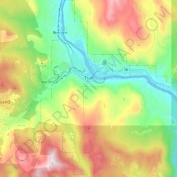
Name: Topografische Karte Trail, Höhe, Relief.
Durchschnittliche Höhe: 934 m
Minimale Höhe: 398 m
Maximale Höhe: 1.638 m
Summer climate in Trail is generally hot and dry with moderately cool nights. Temperatures often exceed 35 °C (95 °F) during summer afternoons, average 29 °C (84 °F). Thunderstorms are common during the late-spring and summer season, often moving into the valley from the south. The fall months bring dense river fog, especially overnight and in the morning, as a cold air inversion lingers above the relatively warm river surface. Winters are mild to cold with periods of moderate snowfall. Nearby villages such as Warfield, Fruitvale and especially Rossland receive greater amounts of snow due to higher elevation.
Andere topografische Karten
Klicken Sie auf eine Karte, um ihre Topografie, ihre Höhe und ihr Relief anzuzeigen.
Area B (Lower Columbia/Old Glory)
Canada > British Columbia > Regional District of Kootenay Boundary
Area B (Lower Columbia/Old Glory), Regional District of Kootenay Boundary, British Columbia, Canada
Durchschnittliche Höhe: 1.246 m
Area E (Beaverdell/West Boundary)
Canada > British Columbia > Regional District of Kootenay Boundary
Area E (Beaverdell/West Boundary), Regional District of Kootenay Boundary, British Columbia, Canada
Durchschnittliche Höhe: 1.241 m
Grand Forks
Canada > British Columbia > Regional District of Kootenay Boundary
Grand Forks, Regional District of Kootenay Boundary, British Columbia, Canada
Durchschnittliche Höhe: 586 m
Record Mountain
Canada > British Columbia > Regional District of Kootenay Boundary > Rossland
Record Mountain, Rossland, Regional District of Kootenay Boundary, British Columbia, Canada
Durchschnittliche Höhe: 1.802 m
Greenwood Water Supply
Canada > British Columbia > Regional District of Kootenay Boundary > Area E (Beaverdell/West Boundary)
Greenwood Water Supply, Area E (Beaverdell/West Boundary), Regional District of Kootenay Boundary, British Columbia, Canada
Durchschnittliche Höhe: 922 m
Greenwood
Canada > British Columbia > Regional District of Kootenay Boundary
Greenwood, Regional District of Kootenay Boundary, British Columbia, V0H 1J0, Canada
Durchschnittliche Höhe: 902 m
Rossland
Canada > British Columbia > Regional District of Kootenay Boundary
Rossland, Regional District of Kootenay Boundary, British Columbia, V0G 1Y0, Canada
Durchschnittliche Höhe: 1.128 m