
Topografische Karte Kootenay National Park
Interaktive Karte
Klicken Sie auf die Karte, um die Höhe anzuzeigen.
Über diese Karte
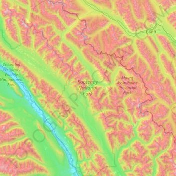
Name: Topografische Karte Kootenay National Park, Höhe, Relief.
Durchschnittliche Höhe: 1.833 m
Minimale Höhe: 785 m
Maximale Höhe: 3.576 m
Kootenay National Park is a national park of Canada located in southeastern British Columbia. The park consists of 1,406 km2 (543 sq mi) of the Canadian Rockies, including parts of the Kootenay and Park mountain ranges, the Kootenay River and the entirety of the Vermilion River. While the Vermilion River is completely contained within the park, the Kootenay River has its headwaters just outside the park boundary, flowing through the park into the Rocky Mountain Trench and eventually joining the Columbia River. The park ranges in elevation from 918 m (3,012 ft) at the southwestern park entrance to 3,424 m (11,234 ft) at Deltaform Mountain.
Andere topografische Karten
Klicken Sie auf eine Karte, um ihre Topografie, ihre Höhe und ihr Relief anzuzeigen.
Cascade Mountain
Canada > Alberta > Improvement District No. 9
Cascade Mountain, Improvement District No. 9, Alberta, T1L 1H8, Canada
Durchschnittliche Höhe: 2.363 m
Kootenay National Park
Canada > Alberta > Improvement District No. 9
Kootenay National Park, Improvement District No. 9, Alberta, Canada
Durchschnittliche Höhe: 1.833 m
Saskatchewan Glacier
Canada > Alberta > Improvement District No. 9
Saskatchewan Glacier, Improvement District No. 9, Alberta, Canada
Durchschnittliche Höhe: 2.255 m
Bow Glacier
Canada > Alberta > Improvement District No. 9
Bow Glacier, Improvement District No. 9, Alberta, Canada
Durchschnittliche Höhe: 2.489 m
Mount Assiniboine
Canada > Alberta > Improvement District No. 9
Mount Assiniboine, Improvement District No. 9, Alberta, Canada
Durchschnittliche Höhe: 2.762 m
Peyto Glacier
Canada > Alberta > Improvement District No. 9
Peyto Glacier, Improvement District No. 9, Alberta, Canada
Durchschnittliche Höhe: 2.421 m
Mount Forbes
Canada > Alberta > Improvement District No. 9
Mount Forbes, Improvement District No. 9, Alberta, Canada
Durchschnittliche Höhe: 2.833 m