
Spenden
Rüsten Sie sich für Ihr nächstes Abenteuer:
Als Amazon-Partner erhält diese Website eine Provision für qualifizierte Käufe, ohne zusätzliche Kosten für Sie.
Topografische Karte Lee Vining
Klicken Sie auf die Karte, um die Höhe anzuzeigen.
Spenden
Rüsten Sie sich für Ihr nächstes Abenteuer:
Als Amazon-Partner erhält diese Website eine Provision für qualifizierte Käufe, ohne zusätzliche Kosten für Sie.
Lee Vining
Lee Vining (formerly Leevining, Poverty Flat, and Lakeview) is an unincorporated community and census-designated place (CDP) in Mono County, California, United States. It is located 25 miles (40 km) south-southeast of Bridgeport, at an elevation of 6,781 feet (2,067 m). Lee Vining is located on the southwest shore of Mono Lake. The population was 217 as of the 2020 census.
Spenden
Rüsten Sie sich für Ihr nächstes Abenteuer:
Als Amazon-Partner erhält diese Website eine Provision für qualifizierte Käufe, ohne zusätzliche Kosten für Sie.
Über diese Karte
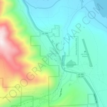
Name: Topografische Karte Lee Vining, Höhe, Relief.
Ort: Lee Vining, Mono County, California, 93541, United States (37.93743 -119.14182 37.97743 -119.10182)
Durchschnittliche Höhe: 2.180 m
Minimale Höhe: 1.945 m
Maximale Höhe: 2.768 m
Spenden
Rüsten Sie sich für Ihr nächstes Abenteuer:
Als Amazon-Partner erhält diese Website eine Provision für qualifizierte Käufe, ohne zusätzliche Kosten für Sie.
Andere topografische Karten
Klicken Sie auf eine Karte, um ihre Topografie, ihre Höhe und ihr Relief anzuzeigen.
Spenden
Rüsten Sie sich für Ihr nächstes Abenteuer:
Als Amazon-Partner erhält diese Website eine Provision für qualifizierte Käufe, ohne zusätzliche Kosten für Sie.
Mono Lake
United States > California > Mono County
Lake Russell was the prehistoric predecessor to Mono Lake, during the Pleistocene. Its shoreline reached the modern-day elevation of 7,480 feet (2,280 m), about 1,100 feet (330 m) higher than the present-day lake. As of 1.6 million years ago, Lake Russell discharged to the northeast, into the Walker River…
Durchschnittliche Höhe: 2.008 m
Spenden
Rüsten Sie sich für Ihr nächstes Abenteuer:
Als Amazon-Partner erhält diese Website eine Provision für qualifizierte Käufe, ohne zusätzliche Kosten für Sie.