Geolokalisieren

Topografische Karte Autheuil

Interaktive Karte

Klicken Sie auf die Karte, um die Höhe anzuzeigen.

Über diese Karte

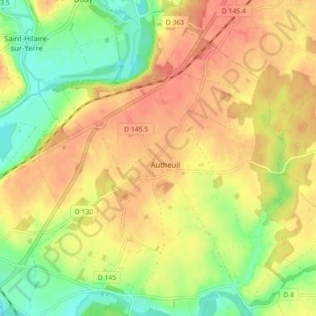
Name: Topografische Karte Autheuil, Höhe, Relief.

Ort: Autheuil, Cloyes-les-Trois-Rivières, Châteaudun, Eure-et-Loir, Centre-Val de Loire, France métropolitaine, 28220, France (47.98743 1.25784 48.03037 1.33735)

Durchschnittliche Höhe: 123 m

Minimale Höhe: 94 m

Maximale Höhe: 143 m

Andere topografische Karten

Klicken Sie auf eine Karte, um ihre Topografie, ihre Höhe und ihr Relief anzuzeigen.

Romilly-sur-Aigre

France > Centre-Val de Loire > Eure-et-Loir > Cloyes-les-Trois-Rivières

Romilly-sur-Aigre, Cloyes-les-Trois-Rivières, Châteaudun, Eure-et-Loir, Centre-Val de Loire, France métropolitaine, 28220, France

Durchschnittliche Höhe: 118 m

Saint-Hilaire-sur-Yerre

France > Centre-Val de Loire > Eure-et-Loir > Cloyes-les-Trois-Rivières

Saint-Hilaire-sur-Yerre, Cloyes-les-Trois-Rivières, Châteaudun, Eure-et-Loir, Centre-Val de Loire, France métropolitaine, 28220, France

Durchschnittliche Höhe: 135 m

Charray

France > Centre-Val de Loire > Eure-et-Loir > Cloyes-les-Trois-Rivières

Charray, Cloyes-les-Trois-Rivières, Châteaudun, Eure-et-Loir, Centre-Val de Loire, France métropolitaine, 28220, France

Durchschnittliche Höhe: 124 m

Cloyes-sur-le-Loir

France > Centre-Val de Loire > Eure-et-Loir > Cloyes-les-Trois-Rivières

Cloyes-sur-le-Loir, Cloyes-les-Trois-Rivières, Châteaudun, Eure-et-Loir, Centre-Val de Loire, France métropolitaine, 28220, France

Durchschnittliche Höhe: 127 m

La Ferandière

France > Centre-Val de Loire > Eure-et-Loir > Cloyes-les-Trois-Rivières

La Ferandière, Autheuil, Cloyes-les-Trois-Rivières, Châteaudun, Eure-et-Loir, Centre-Val de Loire, France métropolitaine, 28220, France

Durchschnittliche Höhe: 129 m