
Topografische Karte Providencia
Interaktive Karte
Klicken Sie auf die Karte, um die Höhe anzuzeigen.
Über diese Karte
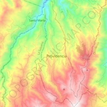
Name: Topografische Karte Providencia, Höhe, Relief.
Ort: Providencia, Los Abades, Nariño, Colombia (1.17816 -77.62326 1.30603 -77.55884)
Durchschnittliche Höhe: 2.431 m
Minimale Höhe: 1.587 m
Maximale Höhe: 3.363 m
Andere topografische Karten
Klicken Sie auf eine Karte, um ihre Topografie, ihre Höhe und ihr Relief anzuzeigen.
Comuna 9
Colombia > Nariño > Pasto > Perímetro Urbano Pasto
Comuna 9, Perímetro Urbano Pasto, Pasto, Centro, Nariño, RAP Pacífico, Colombia
Durchschnittliche Höhe: 2.617 m
San Bernardo
San Bernardo, Río Mayo, Nariño, RAP Pacífico, Colombia
Durchschnittliche Höhe: 2.480 m
Albán (San José)
Albán (San José), Río Mayo, Nariño, RAP Pacífico, Colombia
Durchschnittliche Höhe: 2.050 m
San Lorenzo
San Lorenzo, Juanambú, Nariño, RAP Pacífico, Colombia
Durchschnittliche Höhe: 1.588 m
Sotomayor (Los Andes)
Colombia > Nariño > Los Andes Sotomayor
Sotomayor (Los Andes), Los Andes Sotomayor, Guambuyaco, Nariño, RAP Pacífico, Colombia
Durchschnittliche Höhe: 1.502 m
Perímetro Urbano Pasto
Perímetro Urbano Pasto, Pasto, Centro, Nariño, RAP Pacífico, Colombia
Durchschnittliche Höhe: 2.676 m
Olaya Herrera (Bocas de Satinga)
Colombia > Nariño > Olaya Herrera (Bocas de Satinga)
Olaya Herrera (Bocas de Satinga), Sanquianga, Nariño, Colombia
Durchschnittliche Höhe: 13 m
Comuna 1
Colombia > Nariño > Pasto > Perímetro Urbano Pasto
Comuna 1, Perímetro Urbano Pasto, Pasto, Centro, Nariño, 520003, Colombia
Durchschnittliche Höhe: 2.562 m
Arboleda (Berruecos)
Colombia > Nariño > Arboleda (Berruecos)
Arboleda (Berruecos), Juanambú, Nariño, Colombia
Durchschnittliche Höhe: 1.950 m
Comuna 4
Colombia > Nariño > Pasto > Perímetro Urbano Pasto
Comuna 4, Perímetro Urbano Pasto, Pasto, Centro, Nariño, Colombia
Durchschnittliche Höhe: 2.606 m
Villa Ángela
Villa Ángela, Pasto, Nariño, Colombia
Durchschnittliche Höhe: 2.601 m
Loma Del Medio
Loma Del Medio, Chachagüí, Nariño, Colombia
Durchschnittliche Höhe: 2.429 m
Laguna de la Cocha
Colombia > Nariño > El Romerillo
Laguna de la Cocha, El Romerillo, Nariño, Colombia
Durchschnittliche Höhe: 2.966 m