
Topografische Karte La Spezia
Interaktive Karte
Klicken Sie auf die Karte, um die Höhe anzuzeigen.
Über diese Karte
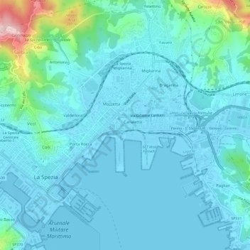
Name: Topografische Karte La Spezia, Höhe, Relief.
Ort: La Spezia, Follo, La Spezia, Liguria, Italy (44.09906 9.79646 44.12501 9.85458)
Durchschnittliche Höhe: 35 m
Minimale Höhe: -3 m
Maximale Höhe: 274 m
Because of its topography, the city is not exposed to winds from the north, which lap western Liguria, but to those from the southeast. These may bring heavy rain and they can reach 80 kilometres per hour (50 mph), in rare cases causing the blocking of the port. The only northern wind reaching the city is the north-eastern Grecale, common during incursions of Arctic air, when the cold air flowing over the warmer Tyrrhenian sea triggers the formation of low pressures, draining the colder and heavier air trapped in the Po Valley, behind the Apennine Mountains.
Andere topografische Karten
Klicken Sie auf eine Karte, um ihre Topografie, ihre Höhe und ihr Relief anzuzeigen.
Cinque Terre
Italy > Liguria > La Spezia > Vernazza
Cinque Terre, Vernazza, Follo, La Spezia, Liguria, 19010, Italy
Durchschnittliche Höhe: 221 m
Riomaggiore
Riomaggiore, La Spezia, Liguria, 19017, Italy
Durchschnittliche Höhe: 250 m