
Spenden
Rüsten Sie sich für Ihr nächstes Abenteuer:
Als Amazon-Partner erhält diese Website eine Provision für qualifizierte Käufe, ohne zusätzliche Kosten für Sie.
Topografische Karte Rustburg
Klicken Sie auf die Karte, um die Höhe anzuzeigen.
Spenden
Rüsten Sie sich für Ihr nächstes Abenteuer:
Als Amazon-Partner erhält diese Website eine Provision für qualifizierte Käufe, ohne zusätzliche Kosten für Sie.
Rustburg
Rustburg is located in north-central Campbell County at 37°16′25″N 79°05′56″W / 37.273731°N 79.098914°W / 37.273731; -79.098914 (37.273731, −79.098914). U.S. Route 501 passes through the center of town, leading north 11 miles (18 km) to Lynchburg and south 20 miles (32 km) to Brookneal. Virginia Route 24 also leads through the center of town, running northeast 9 miles (14 km) to Concord and west 5 miles (8 km) to U.S. Route 29 at Yellow Branch. Long Mountain, topped with communication towers, rises to a summit elevation of 1,440 feet (440 m) northeast of the center of town.
Spenden
Rüsten Sie sich für Ihr nächstes Abenteuer:
Als Amazon-Partner erhält diese Website eine Provision für qualifizierte Käufe, ohne zusätzliche Kosten für Sie.
Über diese Karte
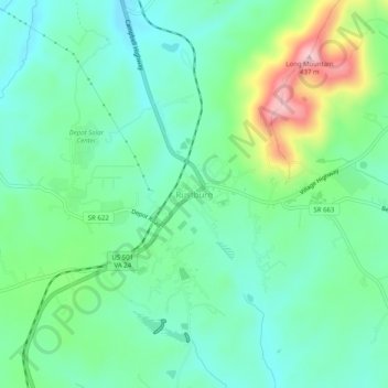
Name: Topografische Karte Rustburg, Höhe, Relief.
Ort: Rustburg, Campbell County, Virginia, 24588, United States (37.25681 -79.12085 37.29681 -79.08085)
Durchschnittliche Höhe: 272 m
Minimale Höhe: 212 m
Maximale Höhe: 429 m
Spenden
Rüsten Sie sich für Ihr nächstes Abenteuer:
Als Amazon-Partner erhält diese Website eine Provision für qualifizierte Käufe, ohne zusätzliche Kosten für Sie.
Andere topografische Karten
Klicken Sie auf eine Karte, um ihre Topografie, ihre Höhe und ihr Relief anzuzeigen.
Rustburg
United States > Virginia > Campbell County
Rustburg is located in north-central Campbell County at 37°16′25″N 79°05′56″W / 37.273731°N 79.098914°W / 37.273731; -79.098914 (37.273731, −79.098914). U.S. Route 501 passes through the center of town, leading north 11 miles (18 km) to Lynchburg and south 20 miles (32 km) to Brookneal.…
Durchschnittliche Höhe: 262 m
Spenden
Rüsten Sie sich für Ihr nächstes Abenteuer:
Als Amazon-Partner erhält diese Website eine Provision für qualifizierte Käufe, ohne zusätzliche Kosten für Sie.