
Topografische Karte Forest Lake
Interaktive Karte
Klicken Sie auf die Karte, um die Höhe anzuzeigen.
Über diese Karte
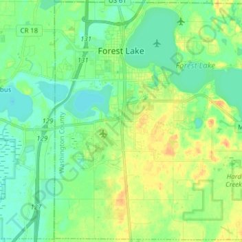
Name: Topografische Karte Forest Lake, Höhe, Relief.
Durchschnittliche Höhe: 279 m
Minimale Höhe: 267 m
Maximale Höhe: 298 m
Andere topografische Karten
Klicken Sie auf eine Karte, um ihre Topografie, ihre Höhe und ihr Relief anzuzeigen.
Woodbury
United States > Minnesota > Washington County
Woodbury, Washington County, Minnesota, United States
Durchschnittliche Höhe: 297 m
Twin Pine Mobile Home Park
United States > Minnesota > Washington County > Hugo
Twin Pine Mobile Home Park, Hugo, Washington County, Minnesota, 55038, United States
Durchschnittliche Höhe: 282 m
Afton
United States > Minnesota > Washington County
Afton, Washington County, Minnesota, 55001, United States
Durchschnittliche Höhe: 259 m
Oakdale
United States > Minnesota > Washington County > Oakdale
Oakdale, Washington County, Minnesota, 55128, United States
Durchschnittliche Höhe: 302 m
Grey Cloud Island
United States > Minnesota > Washington County > Grey Cloud Island
Grey Cloud Island, Washington County, Minnesota, United States
Durchschnittliche Höhe: 221 m
Cottage Grove
United States > Minnesota > Washington County > Cottage Grove
Cottage Grove, Washington County, Minnesota, United States
Durchschnittliche Höhe: 250 m