
Spenden
Rüsten Sie sich für Ihr nächstes Abenteuer:
Als Amazon-Partner erhält diese Website eine Provision für qualifizierte Käufe, ohne zusätzliche Kosten für Sie.
Topografische Karte Camanche Village
Klicken Sie auf die Karte, um die Höhe anzuzeigen.
Spenden
Rüsten Sie sich für Ihr nächstes Abenteuer:
Als Amazon-Partner erhält diese Website eine Provision für qualifizierte Käufe, ohne zusätzliche Kosten für Sie.
Über diese Karte
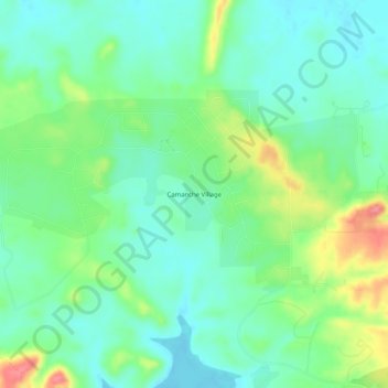
Name: Topografische Karte Camanche Village, Höhe, Relief.
Ort: Camanche Village, Amador County, California, United States (38.24992 -120.99327 38.28992 -120.95327)
Durchschnittliche Höhe: 91 m
Minimale Höhe: 66 m
Maximale Höhe: 147 m
Spenden
Rüsten Sie sich für Ihr nächstes Abenteuer:
Als Amazon-Partner erhält diese Website eine Provision für qualifizierte Käufe, ohne zusätzliche Kosten für Sie.
Andere topografische Karten
Klicken Sie auf eine Karte, um ihre Topografie, ihre Höhe und ihr Relief anzuzeigen.
Jackson
United States > California > Amador County
The area was inhabited by the Northern Sierra Indians, who occupied areas along creeks, spring, and seep areas, including permanent and seasonal drainages, flat ridges, and terraces. Therefore, areas along watercourses are considered likely locations for prehistoric cultural resources. Permanent villages were…
Durchschnittliche Höhe: 421 m
Spenden
Rüsten Sie sich für Ihr nächstes Abenteuer:
Als Amazon-Partner erhält diese Website eine Provision für qualifizierte Käufe, ohne zusätzliche Kosten für Sie.
Volcano
United States > California > Amador County > Volcano
Volcano (formerly Soldier's Gulch and The Volcano) is a census-designated place in Amador County, California. It lies at an elevation of 2,070 feet (631 m). The population was 104 at the 2020 census. It is located at 38°26′35″N 120°37′51″W / 38.44306°N 120.63083°W / 38.44306; -120.63083,…
Durchschnittliche Höhe: 748 m
Jackson
United States > California > Amador County
The area was inhabited by the Northern Sierra Indians, who occupied areas along creeks, spring, and seep areas, including permanent and seasonal drainages, flat ridges, and terraces. Therefore, areas along watercourses are considered likely locations for prehistoric cultural resources. Permanent villages were…
Durchschnittliche Höhe: 421 m
Spenden
Rüsten Sie sich für Ihr nächstes Abenteuer:
Als Amazon-Partner erhält diese Website eine Provision für qualifizierte Käufe, ohne zusätzliche Kosten für Sie.
Jackson
United States > California > Amador County
The area was inhabited by the Northern Sierra Indians, who occupied areas along creeks, spring, and seep areas, including permanent and seasonal drainages, flat ridges, and terraces. Therefore, areas along watercourses are considered likely locations for prehistoric cultural resources. Permanent villages were…
Durchschnittliche Höhe: 421 m