
Topografische Karte Junction City
Interaktive Karte
Klicken Sie auf die Karte, um die Höhe anzuzeigen.
Über diese Karte
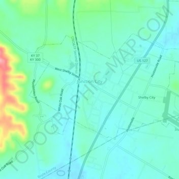
Name: Topografische Karte Junction City, Höhe, Relief.
Ort: Junction City, Boyle County, Kentucky, United States (37.57362 -84.80945 37.59638 -84.76335)
Durchschnittliche Höhe: 312 m
Minimale Höhe: 288 m
Maximale Höhe: 400 m
Andere topografische Karten
Klicken Sie auf eine Karte, um ihre Topografie, ihre Höhe und ihr Relief anzuzeigen.
Danville
United States > Kentucky > Boyle County
Danville, Boyle County, Kentucky, United States
Durchschnittliche Höhe: 290 m
Parksville
United States > Kentucky > Boyle County
Parksville, Boyle County, Kentucky, 40464, United States
Durchschnittliche Höhe: 334 m
West Danville
United States > Kentucky > Boyle County > Danville
West Danville, Danville, Boyle County, Kentucky, United States
Durchschnittliche Höhe: 296 m
Perryville
United States > Kentucky > Boyle County
Perryville, Boyle County, Kentucky, United States
Durchschnittliche Höhe: 274 m