
Topografische Karte Montebelluna
Interaktive Karte
Klicken Sie auf die Karte, um die Höhe anzuzeigen.
Über diese Karte
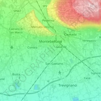
Name: Topografische Karte Montebelluna, Höhe, Relief.
Ort: Montebelluna, Treviso, Veneto, 31044, Italy (45.72298 11.99231 45.81314 12.09770)
Durchschnittliche Höhe: 124 m
Minimale Höhe: 40 m
Maximale Höhe: 369 m
The territory of Montebelluna is largely flat, with altitudes ranging from 69 m a.s.l., found south of San Gaetano, to 144 m, north of Pederiva. The landscape is also characterized by the presence of two hills, including the western end of Montello (where the maximum altitude is, 343 m) and the more modest Capo di Monte (or Montebelluna Alta, or even the hill of Mercato Vecchio, 199 m). Between the two reliefs passes a natural corridor (along which the Feltrina passes), once the original bed of the Piave.
Andere topografische Karten
Klicken Sie auf eine Karte, um ihre Topografie, ihre Höhe und ihr Relief anzuzeigen.
Brioni
Italy > Veneto > Treviso > San Vito di Altivole
Brioni, San Vito di Altivole, Altivole, Fonte, Treviso, Veneto, 31039, Italy
Durchschnittliche Höhe: 83 m
Casale sul Sile
Casale sul Sile, Treviso, Veneto, 31032, Italy
Durchschnittliche Höhe: 6 m