
Topografische Karte Washington
Interaktive Karte
Klicken Sie auf die Karte, um die Höhe anzuzeigen.
Über diese Karte
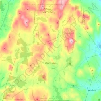
Name: Topografische Karte Washington, Höhe, Relief.
Durchschnittliche Höhe: 466 m
Minimale Höhe: 265 m
Maximale Höhe: 742 m
Lovewell Mountain, located northeast of the town center and with an elevation of 2,496 feet (761 m), is the highest point in town. As Edwin A. Charlton writes in New Hampshire As It Is (1855), the mountain "received its name from Captain John Lovewell, who was accustomed to ascend it for the purpose of discovering the wigwams of the Indians, and who, on one occasion, killed seven Indians near its summit." The Washington Town Common, elevation 1,507 feet (459 m), is the highest town center in the state. (The town hall of Clarksville in northern New Hampshire is located at a higher elevation—1,980 feet (600 m)—but there is no other village development there.)
Andere topografische Karten
Klicken Sie auf eine Karte, um ihre Topografie, ihre Höhe und ihr Relief anzuzeigen.
Plainfield
United States > New Hampshire > Sullivan County
Plainfield, Sullivan County, New Hampshire, United States
Durchschnittliche Höhe: 267 m
Unity
United States > New Hampshire > Sullivan County
Unity, Sullivan County, New Hampshire, United States
Durchschnittliche Höhe: 369 m
Lempster
United States > New Hampshire > Sullivan County
Lempster, Sullivan County, New Hampshire, 03605, United States
Durchschnittliche Höhe: 425 m
Springfield
United States > New Hampshire > Sullivan County > Springfield
Springfield, Sullivan County, New Hampshire, United States
Durchschnittliche Höhe: 416 m
Charlestown
United States > New Hampshire > Sullivan County
Charlestown, Sullivan County, New Hampshire, 03603, United States
Durchschnittliche Höhe: 256 m
Claremont
United States > New Hampshire > Sullivan County
Claremont, Sullivan County, New Hampshire, United States
Durchschnittliche Höhe: 236 m