
Spenden
Rüsten Sie sich für Ihr nächstes Abenteuer:
Als Amazon-Partner erhält diese Website eine Provision für qualifizierte Käufe, ohne zusätzliche Kosten für Sie.
Topografische Karte Doss
Klicken Sie auf die Karte, um die Höhe anzuzeigen.
Spenden
Rüsten Sie sich für Ihr nächstes Abenteuer:
Als Amazon-Partner erhält diese Website eine Provision für qualifizierte Käufe, ohne zusätzliche Kosten für Sie.
Über diese Karte
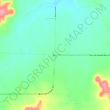
Name: Topografische Karte Doss, Höhe, Relief.
Ort: Doss, Gillespie County, Texas, 78618, United States (30.42464 -99.15060 30.46464 -99.11060)
Durchschnittliche Höhe: 533 m
Minimale Höhe: 502 m
Maximale Höhe: 608 m
Spenden
Rüsten Sie sich für Ihr nächstes Abenteuer:
Als Amazon-Partner erhält diese Website eine Provision für qualifizierte Käufe, ohne zusätzliche Kosten für Sie.
Andere topografische Karten
Klicken Sie auf eine Karte, um ihre Topografie, ihre Höhe und ihr Relief anzuzeigen.
Fredericksburg
United States > Texas > Gillespie County
Enchanted Rock is a geographical landmark 27 km (17 mi) north of Fredericksburg in Llano County. The rock is a huge, pink granite exfoliation dome that rises 425 ft (130 m) above the surrounding land, has a summit elevation of 1,825 ft (556 m) above sea level, and covers 640 acres (260 ha). Enchanted Rock…
Durchschnittliche Höhe: 526 m
Spenden
Rüsten Sie sich für Ihr nächstes Abenteuer:
Als Amazon-Partner erhält diese Website eine Provision für qualifizierte Käufe, ohne zusätzliche Kosten für Sie.