
Spenden
Rüsten Sie sich für Ihr nächstes Abenteuer:
Als Amazon-Partner erhält diese Website eine Provision für qualifizierte Käufe, ohne zusätzliche Kosten für Sie.
Topografische Karte Ponte Vedra Beach
Klicken Sie auf die Karte, um die Höhe anzuzeigen.
Spenden
Rüsten Sie sich für Ihr nächstes Abenteuer:
Als Amazon-Partner erhält diese Website eine Provision für qualifizierte Käufe, ohne zusätzliche Kosten für Sie.
Ponte Vedra Beach
Ponte Vedra Beach is characterized by its gently rolling terrain that is primarily flat and lies only about 15 feet above sea level. The landscape is predominantly shaped by coastal dunes and the proximity to the Atlantic Ocean, resulting in sandy beaches interspersed with vegetation typical of barrier island ecosystems. The area is part of the Guana Tolomato Matanzas National Estuarine Research Reserve, which contributes to its diverse coastal habitats, including estuaries and wetlands. This low-lying terrain is susceptible to erosion and sea level rise, making its elevation a crucial factor in environmental discussions. The interplay between the beach, dunes, and coastal wetlands creates a unique and rich ecosystem that attracts both residents and visitors seeking natural beauty and outdoor activities.
Spenden
Rüsten Sie sich für Ihr nächstes Abenteuer:
Als Amazon-Partner erhält diese Website eine Provision für qualifizierte Käufe, ohne zusätzliche Kosten für Sie.
Über diese Karte
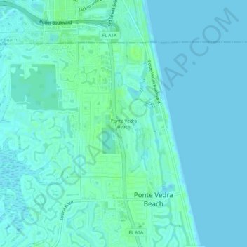
Name: Topografische Karte Ponte Vedra Beach, Höhe, Relief.
Durchschnittliche Höhe: 3 m
Minimale Höhe: -1 m
Maximale Höhe: 9 m
Spenden
Rüsten Sie sich für Ihr nächstes Abenteuer:
Als Amazon-Partner erhält diese Website eine Provision für qualifizierte Käufe, ohne zusätzliche Kosten für Sie.
Andere topografische Karten
Klicken Sie auf eine Karte, um ihre Topografie, ihre Höhe und ihr Relief anzuzeigen.
Palm Valley
United States > Florida > Saint Johns County > Ponte Vedra Beach
Durchschnittliche Höhe: 4 m
DeLeon Shores Park
United States > Florida > Saint Johns County > Ponte Vedra Beach > Palm Valley
Durchschnittliche Höhe: 4 m
Palm Valley
United States > Florida > Saint Johns County > Ponte Vedra Beach
Durchschnittliche Höhe: 4 m
Spenden
Rüsten Sie sich für Ihr nächstes Abenteuer:
Als Amazon-Partner erhält diese Website eine Provision für qualifizierte Käufe, ohne zusätzliche Kosten für Sie.