
Topografische Karte Bolinas
Interaktive Karte
Klicken Sie auf die Karte, um die Höhe anzuzeigen.
Über diese Karte
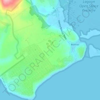
Name: Topografische Karte Bolinas, Höhe, Relief.
Durchschnittliche Höhe: 28 m
Minimale Höhe: -1 m
Maximale Höhe: 149 m
Bolinas sits at an elevation of 36 feet (11 m) above sea level. It is bound on the northeast by Bolinas Lagoon and Kent Island and on the south by Bolinas Bay and Duxbury Point. According to the United States Census Bureau, the CDP has a total area of 5.8 square miles (15 km2), all of it land. The GNIS has cited archaic alternate town-names, including "Ballenas", "Baulenas", "Baulings", and "Bawlines".