
Topografische Karte Koran va Monjan
Interaktive Karte
Klicken Sie auf die Karte, um die Höhe anzuzeigen.
Koran va Monjan
Owing to its altitude, Kuran wa Munjan features a subarctic climate (Dsc) bordering on a tundra climate (ET) under the Köppen climate classification. It has brief, pleasant summers and very cold, snowy winters. Winters are extremely long with below-freezing months from October until May. Summers are very short and the seasonal lag prevailed as August is the warmest month of the year with an average temperature of 10.1 °C (50.2 °F). The coldest month January has an average temperature of −17.2 °C (1.0 °F).
Über diese Karte
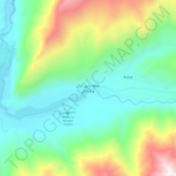
Name: Topografische Karte Koran va Monjan, Höhe, Relief.
Durchschnittliche Höhe: 3.132 m
Minimale Höhe: 2.471 m
Maximale Höhe: 4.724 m
Andere topografische Karten
Klicken Sie auf eine Karte, um ihre Topografie, ihre Höhe und ihr Relief anzuzeigen.
Anjoman
Afghanistan > Badakhshan Province > Kuran wa Munjan
Because of its high altitude, Anjuman enjoys an alpine tundra climate (Köppen climate classification: ET) with short, pleasant summers and long, cold winters. The village lies in the discontinuous permafrost zone, as the average annual temperature reaches −3.2 °C (26.2 °F).
Durchschnittliche Höhe: 3.280 m