
Topografische Karte South-West Oxford
Interaktive Karte
Klicken Sie auf die Karte, um die Höhe anzuzeigen.
Über diese Karte
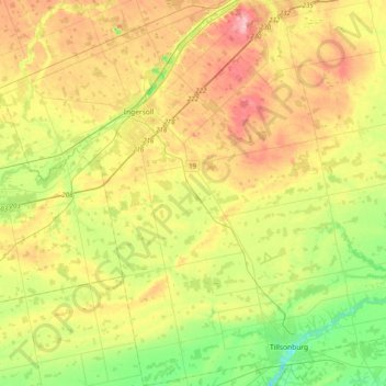
Name: Topografische Karte South-West Oxford, Höhe, Relief.
Durchschnittliche Höhe: 281 m
Minimale Höhe: 201 m
Maximale Höhe: 388 m
In its wilderness state, the former Dereham township had thousands of acres of swamp and marsh land which limited its use for agriculture. Several large drainage projects brought great improvement and remain as essential parts of the township's farmland infrastructure. The township topography still has several large forested areas which are remnants of the original swamps on which drainage system runoff is concentrated.
Andere topografische Karten
Klicken Sie auf eine Karte, um ihre Topografie, ihre Höhe und ihr Relief anzuzeigen.
Oxford
Canada > Ontario > Oxford County > South-West Oxford
Oxford, South-West Oxford, Oxford County, Ontario, Canada
Durchschnittliche Höhe: 297 m
Blenheim
Canada > Ontario > Oxford County > Blandford-Blenheim
Blenheim, Blandford-Blenheim, Oxford County, Ontario, Canada
Durchschnittliche Höhe: 300 m
Blandford-Blenheim
Canada > Ontario > Oxford County
Blandford-Blenheim, Oxford County, Southwestern Ontario, Ontario, Canada
Durchschnittliche Höhe: 305 m
Hickson
Canada > Ontario > Oxford County > East Zorra-Tavistock
Hickson, East Zorra-Tavistock, Oxford County, Southwestern Ontario, Ontario, N0J 1L0, Canada
Durchschnittliche Höhe: 340 m
Norwich
Canada > Ontario > Oxford County
Norwich, Oxford County, Southwestern Ontario, Ontario, Canada
Durchschnittliche Höhe: 268 m
Tillsonburg
Canada > Ontario > Oxford County > Tillsonburg
Tillsonburg, Oxford County, Southwestern Ontario, Ontario, Canada
Durchschnittliche Höhe: 239 m
Woodstock
Canada > Ontario > Oxford County
Woodstock, Oxford County, Southwestern Ontario, Ontario, Canada
Durchschnittliche Höhe: 308 m